Villaguay geodata
Villaguay (Entre Rios) is a seat of a second-order administrative division; located in Argentina in America/Argentina/Cordoba (GMT-3) time zone. With population of 32,027 people, there are 129 cities with bigger population in this country. Compared to other cities in Argentina, 50.3% of cities are located further ↑North; 76.2% of cities are located further ←West and 84.5% of cities have higher elevation than Villaguay. Note1


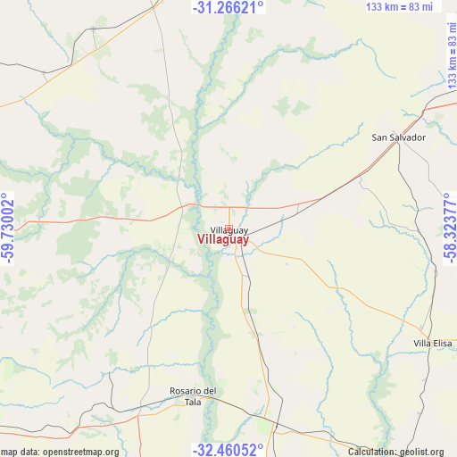
Villaguay GPS coordinates[2]
31° 51' 55.08" South, 59° 1' 36.804" West
| Map corner | latitude | longitude |
|---|---|---|
| Upper-left | -31.26621°, | -59.73002° |
| Center: | -31.8653°, | -59.02689° |
| Lower-right: | -32.46052°, | -58.32377° |
| Map W x H: | 132.8×132.8 km | = 82.5×82.5mi |
| max Lat: | -21.94467° ⇑50.3% North |
| Villaguay: | -31.8653° |
| min Lat: | ⇓49.7% South -54.81084° |
| min Long | Villaguay | max Long |
| -72.88605° | -59.02689° | -53.64581° |
| W 76.2%⇐ | ⇒23.8% E |
Elevation
Elevation of Villaguay is 50 m = 164 ft, and this is 299.3 m = 982 ft below average elevation for this country.
| Max E: |
4040 m = 13255 ft | 84.5% |
| Avg. | 349.3 m = 1146 ft | |
| Villaguay | 50 m = 164 ft | |
Min E: |
-2 m = -7 ft | 15.5% |
See also: Argentina elevation on elevation.city.
Geographical zone
Villaguay is located in South temperate zone (between Tropic of Capricorn and the Antarctic Circle). Distance of this Southern Tropic circle is 937.2 km =582.3 mi to North.| Distance of | km | miles | from Villaguay |
|---|---|---|---|
| Equator | 3543.1 | 2201.6 | to North |
| Tropic Capricorn | 937.2 | 582.3 | to North |
| Antarctic Circle | 3858.1 | 2397.3 | to South |
| South Pole | 6464 | 4016.5 | to South |


Nearby cities:
15 places around Villaguay: (largest is in red/bold)
• Bovril
70.3 km =43.7 mi,  325°
325°
• Domínguez
14.9 km =9.3 mi,  155°
155°
• General Campos
70.1 km =43.6 mi,  57°
57°
• Gilbert
75 km =46.6 mi,  173°
173°
• Herrera
73.4 km =45.6 mi,  149°
149°
• Lucas González
74.7 km =46.4 mi,  219°
219°
• Maciá
49 km =30.4 mi,  225°
225°
• Pronunciamiento
76.6 km =47.6 mi,  134°
134°
• Rosario del Tala
49.9 km =31 mi,  192°
192°
• San Salvador
56.1 km =34.9 mi, 61°
• Santa Anita
41.2 km =25.6 mi, 146°
• Sauce de Luna
72.1 km =44.8 mi,  345°
345°
• Ubajay
67.9 km =42.2 mi,  83°
83°
• Villa Elisa
67.7 km =42.1 mi,  119°
119°
• Villa Mantero
64.8 km =40.3 mi, 155°
Sources, notices
• [Note1] Compared only with cities in Argentina existing in our database
• [Src1] Map data: © OpenStreetMap contributors (CC-BY-SA)
• [Src2] Other city data from geonames.org with taken over terms of usage.
• [Src3] Geographical zone / Annual Mean Temperature by Robert A. Rohde @ Wikipedia
