Los Charrúas geodata
Los Charrúas (Entre Rios) is a populated place; located in Argentina in America/Argentina/Cordoba (GMT-3) time zone. With population of 3,414 people, there are 527 cities with bigger population in this country. Compared to other cities in Argentina, 58.2% of cities are located further ↓South; 87.9% of cities are located further ←West and 73.7% of cities have higher elevation than Los Charrúas. Note1


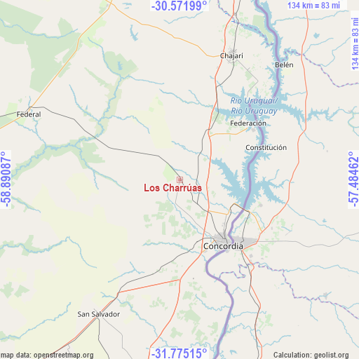
Los Charrúas GPS coordinates[2]
31° 10' 31.728" South, 58° 11' 15.864" West
| Map corner | latitude | longitude |
|---|---|---|
| Upper-left | -30.57199°, | -58.89087° |
| Center: | -31.17548°, | -58.18774° |
| Lower-right: | -31.77515°, | -57.48462° |
| Map W x H: | 133.8×133.8 km | = 83.1×83.1mi |
| max Lat: | -21.94467° ⇑41.8% North |
| Los Charrúas: | -31.17548° |
| min Lat: | ⇓58.2% South -54.81084° |
| min Long | Los Charrúas | max Long |
| -72.88605° | -58.18774° | -53.64581° |
| W 87.9%⇐ | ⇒12.1% E |
Elevation
Elevation of Los Charrúas is 72 m = 236 ft, and this is 277.3 m = 910 ft below average elevation for this country.
| Max E: |
4040 m = 13255 ft | 73.7% |
| Avg. | 349.3 m = 1146 ft | |
| Los Charrúas | 72 m = 236 ft | |
Min E: |
-2 m = -7 ft | 26.3% |
See also: Argentina elevation on elevation.city.
Geographical zone
Los Charrúas is located in South temperate zone (between Tropic of Capricorn and the Antarctic Circle). Distance of this Southern Tropic circle is 860.5 km =534.7 mi to North.| Distance of | km | miles | from Los Charrúas |
|---|---|---|---|
| Equator | 3466.4 | 2153.9 | to North |
| Tropic Capricorn | 860.5 | 534.7 | to North |
| Antarctic Circle | 3934.8 | 2445 | to South |
| South Pole | 6540.7 | 4064.2 | to South |


Nearby cities:
15 places around Los Charrúas: (largest is in red/bold)
• Chajarí
51.3 km =31.9 mi,  22°
22°
• Concordia
28.9 km =18 mi,  146°
146°
• Conscripto Bernardi
86.5 km =53.7 mi,  279°
279°
• Federación
33.3 km =20.7 mi,  55°
55°
• Federal
61.8 km =38.4 mi,  293°
293°
• General Campos
43.8 km =27.2 mi,  208°
208°
• Juan Pujol
89.9 km =55.9 mi, 20°
• La Criolla
13 km =8.1 mi,  143°
143°
• Los Conquistadores
70.3 km =43.7 mi,  337°
337°
• Mocoretá
65.5 km =40.7 mi, 19°
• Puerto Yeruá
43.4 km =27 mi,  157°
157°
• San Salvador
58.3 km =36.2 mi, 211°
• Santa Ana
39.2 km =24.4 mi,  38°
38°
• Ubajay
69.8 km =43.4 mi,  189°
189°
• Villa del Rosario
49.7 km =30.9 mi,  31°
31°
Sources, notices
• [Note1] Compared only with cities in Argentina existing in our database
• [Src1] Map data: © OpenStreetMap contributors (CC-BY-SA)
• [Src2] Other city data from geonames.org with taken over terms of usage.
• [Src3] Geographical zone / Annual Mean Temperature by Robert A. Rohde @ Wikipedia
