General Campos geodata
General Campos (Entre Rios) is a populated place; located in Argentina in America/Argentina/Cordoba (GMT-3) time zone. With population of 2,982 people, there are 554 cities with bigger population in this country. Compared to other cities in Argentina, 53.8% of cities are located further ↓South; 85.2% of cities are located further ←West and 77.4% of cities have higher elevation than General Campos. Note1


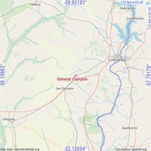
General Campos GPS coordinates[2]
31° 31' 23.196" South, 58° 24' 17.64" West
| Map corner | latitude | longitude |
|---|---|---|
| Upper-left | -30.92183°, | -59.10803° |
| Center: | -31.52311°, | -58.4049° |
| Lower-right: | -32.12054°, | -57.70178° |
| Map W x H: | 133.3×133.3 km | = 82.8×82.8mi |
| max Lat: | -21.94467° ⇑46.2% North |
| General Campos: | -31.52311° |
| min Lat: | ⇓53.8% South -54.81084° |
| min Long | General Campos | max Long |
| -72.88605° | -58.4049° | -53.64581° |
| W 85.2%⇐ | ⇒14.8% E |
Elevation
Elevation of General Campos is 65 m = 213 ft, and this is 284.3 m = 933 ft below average elevation for this country.
| Max E: |
4040 m = 13255 ft | 77.4% |
| Avg. | 349.3 m = 1146 ft | |
| General Campos | 65 m = 213 ft | |
Min E: |
-2 m = -7 ft | 22.6% |
See also: Argentina elevation on elevation.city.
Geographical zone
General Campos is located in South temperate zone (between Tropic of Capricorn and the Antarctic Circle). Distance of this Southern Tropic circle is 899.1 km =558.7 mi to North.| Distance of | km | miles | from General Campos |
|---|---|---|---|
| Equator | 3505 | 2177.9 | to North |
| Tropic Capricorn | 899.1 | 558.7 | to North |
| Antarctic Circle | 3896.1 | 2420.9 | to South |
| South Pole | 6502 | 4040.2 | to South |


Nearby cities:
15 places around General Campos: (largest is in red/bold)
• Colón
81.6 km =50.7 mi,  162°
162°
• Concordia
39.2 km =24.4 mi,  68°
68°
• Conscripto Bernardi
83.4 km =51.8 mi,  309°
309°
• Domínguez
73.7 km =45.8 mi,  225°
225°
• Federación
74.9 km =46.5 mi,  39°
39°
• Federal
72.7 km =45.2 mi,  330°
330°
• La Criolla
40.1 km =24.9 mi,  45°
45°
• Los Charrúas
43.8 km =27.2 mi,  28°
28°
• Puerto Yeruá
37 km =23 mi,  92°
92°
• San Salvador
14.8 km =9.2 mi,  220°
220°
• Santa Ana
82.6 km =51.3 mi, 33°
• Santa Anita
80.9 km =50.3 mi,  206°
206°
• Ubajay
31.3 km =19.4 mi, 163°
• Villa Elisa
71.2 km =44.2 mi,  179°
179°
• Villaguay
70.1 km =43.6 mi,  237°
237°
Sources, notices
• [Note1] Compared only with cities in Argentina existing in our database
• [Src1] Map data: © OpenStreetMap contributors (CC-BY-SA)
• [Src2] Other city data from geonames.org with taken over terms of usage.
• [Src3] Geographical zone / Annual Mean Temperature by Robert A. Rohde @ Wikipedia
