San Salvador geodata
San Salvador (Entre Rios) is a seat of a second-order administrative division; located in Argentina in America/Argentina/Cordoba (GMT-3) time zone. With population of 11,626 people, there are 264 cities with bigger population in this country. Compared to other cities in Argentina, 52.7% of cities are located further ↓South; 83.6% of cities are located further ←West and 72.4% of cities have higher elevation than San Salvador. Note1


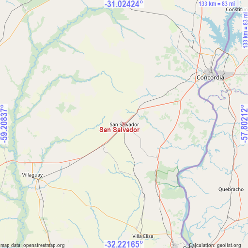
San Salvador GPS coordinates[2]
31° 37' 29.532" South, 58° 30' 18.864" West
| Map corner | latitude | longitude |
|---|---|---|
| Upper-left | -31.02424°, | -59.20837° |
| Center: | -31.62487°, | -58.50524° |
| Lower-right: | -32.22165°, | -57.80212° |
| Map W x H: | 133.1×133.1 km | = 82.7×82.7mi |
| max Lat: | -21.94467° ⇑47.3% North |
| San Salvador: | -31.62487° |
| min Lat: | ⇓52.7% South -54.81084° |
| min Long | San Salvador | max Long |
| -72.88605° | -58.50524° | -53.64581° |
| W 83.6%⇐ | ⇒16.4% E |
Elevation
Elevation of San Salvador is 75 m = 246 ft, and this is 274.3 m = 900 ft below average elevation for this country.
| Max E: |
4040 m = 13255 ft | 72.4% |
| Avg. | 349.3 m = 1146 ft | |
| San Salvador | 75 m = 246 ft | |
Min E: |
-2 m = -7 ft | 27.6% |
See also: Argentina elevation on elevation.city.
Geographical zone
San Salvador is located in South temperate zone (between Tropic of Capricorn and the Antarctic Circle). Distance of this Southern Tropic circle is 910.4 km =565.7 mi to North.| Distance of | km | miles | from San Salvador |
|---|---|---|---|
| Equator | 3516.4 | 2185 | to North |
| Tropic Capricorn | 910.4 | 565.7 | to North |
| Antarctic Circle | 3884.8 | 2413.9 | to South |
| South Pole | 6490.7 | 4033.1 | to South |


Nearby cities:
15 places around San Salvador: (largest is in red/bold)
• Colón
74.7 km =46.4 mi,  152°
152°
• Concordia
52.7 km =32.7 mi,  60°
60°
• Conscripto Bernardi
84.5 km =52.5 mi,  319°
319°
• Domínguez
59 km =36.7 mi,  226°
226°
• Federal
79.1 km =49.2 mi,  340°
340°
• General Campos
14.8 km =9.2 mi,  40°
40°
• La Criolla
54.8 km =34.1 mi, 43°
• Los Charrúas
58.3 km =36.2 mi,  31°
31°
• Pronunciamiento
80.3 km =49.9 mi,  175°
175°
• Puerto Yeruá
47.4 km =29.5 mi,  78°
78°
• Santa Anita
66.6 km =41.4 mi,  203°
203°
• Sauce de Luna
80.2 km =49.8 mi,  302°
302°
• Ubajay
26.1 km =16.2 mi,  135°
135°
• Villa Elisa
60.7 km =37.7 mi,  170°
170°
• Villaguay
56.1 km =34.9 mi,  241°
241°
Sources, notices
• [Note1] Compared only with cities in Argentina existing in our database
• [Src1] Map data: © OpenStreetMap contributors (CC-BY-SA)
• [Src2] Other city data from geonames.org with taken over terms of usage.
• [Src3] Geographical zone / Annual Mean Temperature by Robert A. Rohde @ Wikipedia
