La Criolla geodata
La Criolla (Entre Rios) is a populated place; located in Argentina in America/Argentina/Cordoba (GMT-3) time zone. With population of 1,852 people, there are 660 cities with bigger population in this country. Compared to other cities in Argentina, 57.2% of cities are located further ↓South; 88.4% of cities are located further ←West and 81.2% of cities have higher elevation than La Criolla. Note1


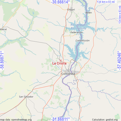
La Criolla GPS coordinates[2]
31° 16' 8.544" South, 58° 6' 20.088" West
| Map corner | latitude | longitude |
|---|---|---|
| Upper-left | -30.66614°, | -58.80871° |
| Center: | -31.26904°, | -58.10558° |
| Lower-right: | -31.86811°, | -57.40246° |
| Map W x H: | 133.6×133.6 km | = 83×83mi |
| max Lat: | -21.94467° ⇑42.8% North |
| La Criolla: | -31.26904° |
| min Lat: | ⇓57.2% South -54.81084° |
| min Long | La Criolla | max Long |
| -72.88605° | -58.10558° | -53.64581° |
| W 88.4%⇐ | ⇒11.6% E |
Elevation
Elevation of La Criolla is 55 m = 180 ft, and this is 294.3 m = 966 ft below average elevation for this country.
| Max E: |
4040 m = 13255 ft | 81.2% |
| Avg. | 349.3 m = 1146 ft | |
| La Criolla | 55 m = 180 ft | |
Min E: |
-2 m = -7 ft | 18.8% |
See also: Argentina elevation on elevation.city.
Geographical zone
La Criolla is located in South temperate zone (between Tropic of Capricorn and the Antarctic Circle). Distance of this Southern Tropic circle is 870.9 km =541.2 mi to North.| Distance of | km | miles | from La Criolla |
|---|---|---|---|
| Equator | 3476.8 | 2160.4 | to North |
| Tropic Capricorn | 870.9 | 541.2 | to North |
| Antarctic Circle | 3924.4 | 2438.5 | to South |
| South Pole | 6530.3 | 4057.7 | to South |


Nearby cities:
15 places around La Criolla: (largest is in red/bold)
• Chajarí
58.9 km =36.6 mi,  11°
11°
• Concordia
16 km =9.9 mi,  149°
149°
• Conscripto Bernardi
96.3 km =59.8 mi,  284°
284°
• Federación
35.2 km =21.9 mi,  33°
33°
• Federal
73.4 km =45.6 mi,  298°
298°
• General Campos
40.1 km =24.9 mi,  225°
225°
• Juan Pujol
97.5 km =60.6 mi, 14°
• Los Charrúas
13 km =8.1 mi,  323°
323°
• Los Conquistadores
82.9 km =51.5 mi,  335°
335°
• Mocoretá
73.5 km =45.7 mi, 10°
• Puerto Yeruá
31 km =19.3 mi,  163°
163°
• San Salvador
54.8 km =34.1 mi,  223°
223°
• Santa Ana
44.2 km =27.5 mi,  21°
21°
• Ubajay
61.6 km =38.3 mi,  198°
198°
• Villa del Rosario
55.8 km =34.7 mi, 19°
Sources, notices
• [Note1] Compared only with cities in Argentina existing in our database
• [Src1] Map data: © OpenStreetMap contributors (CC-BY-SA)
• [Src2] Other city data from geonames.org with taken over terms of usage.
• [Src3] Geographical zone / Annual Mean Temperature by Robert A. Rohde @ Wikipedia
