Larroque geodata
Larroque (Entre Rios) is a populated place; located in Argentina in America/Argentina/Cordoba (GMT-3) time zone. With population of 6,200 people, there are 395 cities with bigger population in this country. Compared to other cities in Argentina, 62.6% of cities are located further ↑North; 76.5% of cities are located further ←West and 82.2% of cities have higher elevation than Larroque. Note1


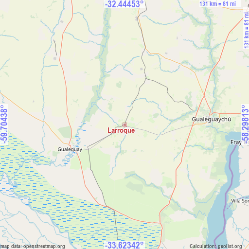
Larroque GPS coordinates[2]
33° 2' 9.42" South, 59° 0' 4.5" West
| Map corner | latitude | longitude |
|---|---|---|
| Upper-left | -32.44453°, | -59.70438° |
| Center: | -33.03595°, | -59.00125° |
| Lower-right: | -33.62342°, | -58.29813° |
| Map W x H: | 131.1×131.1 km | = 81.5×81.5mi |
| max Lat: | -21.94467° ⇑62.6% North |
| Larroque: | -33.03595° |
| min Lat: | ⇓37.4% South -54.81084° |
| min Long | Larroque | max Long |
| -72.88605° | -59.00125° | -53.64581° |
| W 76.5%⇐ | ⇒23.5% E |
Elevation
Elevation of Larroque is 54 m = 177 ft, and this is 295.3 m = 969 ft below average elevation for this country.
| Max E: |
4040 m = 13255 ft | 82.2% |
| Avg. | 349.3 m = 1146 ft | |
| Larroque | 54 m = 177 ft | |
Min E: |
-2 m = -7 ft | 17.8% |
See also: Argentina elevation on elevation.city.
Geographical zone
Larroque is located in South temperate zone (between Tropic of Capricorn and the Antarctic Circle). Distance of this Southern Tropic circle is 1067.3 km =663.2 mi to North.| Distance of | km | miles | from Larroque |
|---|---|---|---|
| Equator | 3673.3 | 2282.5 | to North |
| Tropic Capricorn | 1067.3 | 663.2 | to North |
| Antarctic Circle | 3727.9 | 2316.4 | to South |
| South Pole | 6333.8 | 3935.6 | to South |


Nearby cities:
15 places around Larroque: (largest is in red/bold)
• Aldea San Antonio
53.6 km =33.3 mi,  31°
31°
• Caseros
80.3 km =49.9 mi,  37°
37°
• Ceibas
50 km =31.1 mi,  152°
152°
• Colonia Elía
75 km =46.6 mi,  57°
57°
• General Galarza
50.9 km =31.6 mi,  313°
313°
• Gilbert
56.1 km =34.9 mi,  6°
6°
• Gobernador Mansilla
63.9 km =39.7 mi,  328°
328°
• Gualeguay
31 km =19.3 mi,  247°
247°
• Gualeguaychú
45.2 km =28.1 mi,  86°
86°
• Herrera
75.3 km =46.8 mi, 27°
• Puerto Ibicuy
81.4 km =50.6 mi,  191°
191°
• Rosario del Tala
82.6 km =51.3 mi,  350°
350°
• Urdinarrain
40.2 km =25 mi, 14°
• Villa Mantero
74.9 km =46.5 mi,  18°
18°
• Villa Paranacito
81.8 km =50.8 mi,  157°
157°
Sources, notices
• [Note1] Compared only with cities in Argentina existing in our database
• [Src1] Map data: © OpenStreetMap contributors (CC-BY-SA)
• [Src2] Other city data from geonames.org with taken over terms of usage.
• [Src3] Geographical zone / Annual Mean Temperature by Robert A. Rohde @ Wikipedia
