Ceibas geodata
Ceibas (Entre Rios) is a populated place; located in Argentina in America/Argentina/Cordoba (GMT-3) time zone. With population of 1,405 people, there are 714 cities with bigger population in this country. Compared to other cities in Argentina, 66% of cities are located further ↑North; 79.5% of cities are located further ←West and 99% of cities have higher elevation than Ceibas. Note1


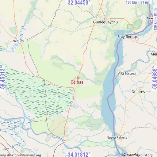
Ceibas GPS coordinates[2]
33° 25' 59.988" South, 58° 45' 0" West
| Map corner | latitude | longitude |
|---|---|---|
| Upper-left | -32.84458°, | -59.45313° |
| Center: | -33.43333°, | -58.75° |
| Lower-right: | -34.01812°, | -58.04688° |
| Map W x H: | 130.5×130.5 km | = 81.1×81.1mi |
| max Lat: | -21.94467° ⇑66% North |
| Ceibas: | -33.43333° |
| min Lat: | ⇓34% South -54.81084° |
| min Long | Ceibas | max Long |
| -72.88605° | -58.75° | -53.64581° |
| W 79.5%⇐ | ⇒20.5% E |
Elevation
Elevation of Ceibas is 7 m = 23 ft, and this is 342.3 m = 1123 ft below average elevation for this country.
| Max E: |
4040 m = 13255 ft | 99% |
| Avg. | 349.3 m = 1146 ft | |
| Ceibas | 7 m = 23 ft | |
Min E: |
-2 m = -7 ft | 1% |
See also: Argentina elevation on elevation.city.
Geographical zone
Ceibas is located in South temperate zone (between Tropic of Capricorn and the Antarctic Circle). Distance of this Southern Tropic circle is 1111.5 km =690.7 mi to North.| Distance of | km | miles | from Ceibas |
|---|---|---|---|
| Equator | 3717.4 | 2309.9 | to North |
| Tropic Capricorn | 1111.5 | 690.7 | to North |
| Antarctic Circle | 3683.7 | 2288.9 | to South |
| South Pole | 6289.6 | 3908.2 | to South |


Nearby cities:
15 places around Ceibas: (largest is in red/bold)
• Aldea San Antonio
90.2 km =56 mi,  2°
2°
• Baradero
81.8 km =50.8 mi,  239°
239°
• Campana
83.4 km =51.8 mi,  193°
193°
• Capilla del Señor
100.9 km =62.7 mi,  198°
198°
• Colonia Elía
93.5 km =58.1 mi,  25°
25°
• General Galarza
99.5 km =61.8 mi,  322°
322°
• Gilbert
101.3 km =62.9 mi,  350°
350°
• Gualeguay
61.3 km =38.1 mi,  301°
301°
• Gualeguaychú
51.9 km =32.2 mi,  24°
24°
• Larroque
50 km =31.1 mi,  332°
332°
• Puerto Ibicuy
53.2 km =33.1 mi,  228°
228°
• San Pedro
89.2 km =55.4 mi,  252°
252°
• Urdinarrain
84.2 km =52.3 mi, 350°
• Villa Paranacito
32.3 km =20.1 mi,  164°
164°
• Zárate
78.3 km =48.7 mi, 199°
Sources, notices
• [Note1] Compared only with cities in Argentina existing in our database
• [Src1] Map data: © OpenStreetMap contributors (CC-BY-SA)
• [Src2] Other city data from geonames.org with taken over terms of usage.
• [Src3] Geographical zone / Annual Mean Temperature by Robert A. Rohde @ Wikipedia
