Los Cóndores geodata
Los Cóndores (Cordoba) is a populated place; located in Argentina in America/Argentina/Cordoba (GMT-3) time zone. With population of 2,720 people, there are 575 cities with bigger population in this country. Compared to other cities in Argentina, 54.8% of cities are located further ↑North; 64.2% of cities are located further →East and 79.1% of cities have lower elevation than Los Cóndores. Note1


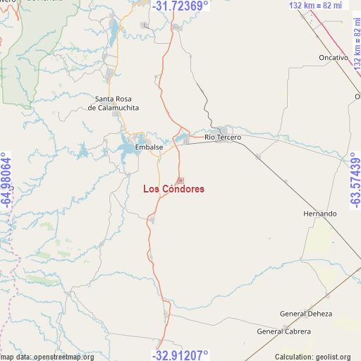
Los Cóndores GPS coordinates[2]
32° 19' 11.388" South, 64° 16' 39.036" West
| Map corner | latitude | longitude |
|---|---|---|
| Upper-left | -31.72369°, | -64.98064° |
| Center: | -32.31983°, | -64.27751° |
| Lower-right: | -32.91207°, | -63.57439° |
| Map W x H: | 132.1×132.1 km | = 82.1×82.1mi |
| max Lat: | -21.94467° ⇑54.8% North |
| Los Cóndores: | -32.31983° |
| min Lat: | ⇓45.2% South -54.81084° |
| min Long | Los Cóndores | max Long |
| -72.88605° | -64.27751° | -53.64581° |
| W 35.8%⇐ | ⇒64.2% E |
Elevation
Elevation of Los Cóndores is 542 m = 1778 ft, and this is 192.7 m = 632 ft above average elevation for this country.
| Max E: |
4040 m = 13255 ft | 20.9% |
| Los Cóndores | 542 m 1778 ft | |
| Avg. | 349.3 m = 1146 ft | |
Min E: |
-2 m = -7 ft | 79.1% |
See also: Argentina elevation on elevation.city.
Geographical zone
Los Cóndores is located in South temperate zone (between Tropic of Capricorn and the Antarctic Circle). Distance of this Southern Tropic circle is 987.7 km =613.7 mi to North.| Distance of | km | miles | from Los Cóndores |
|---|---|---|---|
| Equator | 3593.6 | 2233 | to North |
| Tropic Capricorn | 987.7 | 613.7 | to North |
| Antarctic Circle | 3807.5 | 2365.9 | to South |
| South Pole | 6413.4 | 3985.1 | to South |


Nearby cities:
15 places around Los Cóndores: (largest is in red/bold)
• Almafuerte
14.3 km =8.9 mi,  8°
8°
• Berrotarán
17.9 km =11.1 mi,  215°
215°
• Corralito
33.8 km =21 mi, 13°
• Despeñaderos
56 km =34.8 mi,  358°
358°
• Elena
30.1 km =18.7 mi,  201°
201°
• Embalse
20.4 km =12.7 mi,  319°
319°
• Hernando
52.5 km =32.6 mi,  103°
103°
• Río Tercero
22.4 km =13.9 mi,  43°
43°
• San Agustín
39.2 km =24.4 mi,  346°
346°
• Santa Rosa de Calamuchita
37 km =23 mi, 318°
• Tancacha
29.2 km =18.1 mi,  72°
72°
• Villa Ascasubi
40.2 km =25 mi,  64°
64°
• Villa General Belgrano
46.2 km =28.7 mi,  325°
325°
• Villa Rumipal
24.1 km =15 mi,  307°
307°
• Villa del Dique
23.1 km =14.4 mi, 313°
Sources, notices
• [Note1] Compared only with cities in Argentina existing in our database
• [Src1] Map data: © OpenStreetMap contributors (CC-BY-SA)
• [Src2] Other city data from geonames.org with taken over terms of usage.
• [Src3] Geographical zone / Annual Mean Temperature by Robert A. Rohde @ Wikipedia
