Uriburu geodata
Uriburu (La Pampa) is a populated place; located in Argentina in America/Argentina/Salta (GMT-3) time zone. With population of 1,200 people, there are 740 cities with bigger population in this country. Compared to other cities in Argentina, 83.6% of cities are located further ↑North; 59.5% of cities are located further →East and 50.1% of cities have lower elevation than Uriburu. Note1


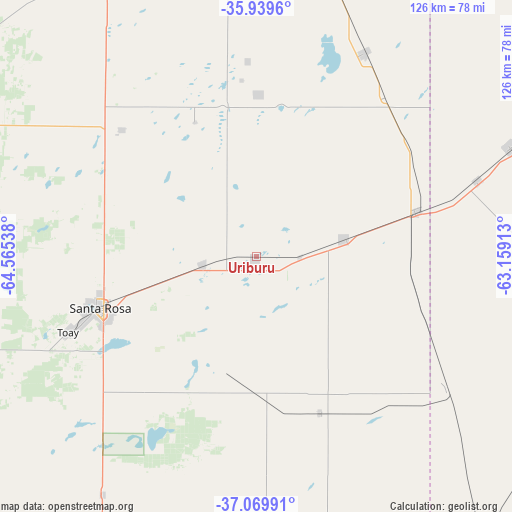
Uriburu GPS coordinates[2]
36° 30' 24.552" South, 63° 51' 44.1" West
| Map corner | latitude | longitude |
|---|---|---|
| Upper-left | -35.9396°, | -64.56538° |
| Center: | -36.50682°, | -63.86225° |
| Lower-right: | -37.06991°, | -63.15913° |
| Map W x H: | 125.7×125.7 km | = 78.1×78.1mi |
| max Lat: | -21.94467° ⇑83.6% North |
| Uriburu: | -36.50682° |
| min Lat: | ⇓16.4% South -54.81084° |
| min Long | Uriburu | max Long |
| -72.88605° | -63.86225° | -53.64581° |
| W 40.5%⇐ | ⇒59.5% E |
Elevation
Elevation of Uriburu is 144 m = 472 ft, and this is 205.3 m = 674 ft below average elevation for this country.
| Max E: |
4040 m = 13255 ft | 49.9% |
| Avg. | 349.3 m = 1146 ft | |
| Uriburu | 144 m = 472 ft | |
Min E: |
-2 m = -7 ft | 50.1% |
See also: Argentina elevation on elevation.city.
Geographical zone
Uriburu is located in South temperate zone (between Tropic of Capricorn and the Antarctic Circle). Distance of this Southern Tropic circle is 1453.3 km =903 mi to North.| Distance of | km | miles | from Uriburu |
|---|---|---|---|
| Equator | 4059.2 | 2522.3 | to North |
| Tropic Capricorn | 1453.3 | 903 | to North |
| Antarctic Circle | 3342 | 2076.6 | to South |
| South Pole | 5947.9 | 3695.9 | to South |


Nearby cities:
15 places around Uriburu: (largest is in red/bold)
• Anguil
13.4 km =8.3 mi,  260°
260°
• Ataliva Roca
69.4 km =43.1 mi,  212°
212°
• Catriló
41 km =25.5 mi,  74°
74°
• Colonia Barón
39.5 km =24.5 mi,  1°
1°
• Doblas
72.7 km =45.2 mi,  190°
190°
• Eduardo Castex
76.4 km =47.5 mi,  329°
329°
• Lonquimay
21.8 km =13.5 mi,  77°
77°
• Macachín
72.1 km =44.8 mi,  166°
166°
• Miguel Riglos
41.6 km =25.8 mi,  158°
158°
• Pellegrini
67.9 km =42.2 mi, 66°
• Quemú Quemú
56.9 km =35.4 mi,  27°
27°
• Salliqueló
85 km =52.8 mi,  108°
108°
• Santa Rosa
39.5 km =24.5 mi,  252°
252°
• Toay
49.7 km =30.9 mi, 248°
• Winifreda
45.6 km =28.3 mi,  313°
313°
Sources, notices
• [Note1] Compared only with cities in Argentina existing in our database
• [Src1] Map data: © OpenStreetMap contributors (CC-BY-SA)
• [Src2] Other city data from geonames.org with taken over terms of usage.
• [Src3] Geographical zone / Annual Mean Temperature by Robert A. Rohde @ Wikipedia
