Anguil geodata
Anguil (La Pampa) is a populated place; located in Argentina in America/Argentina/Salta (GMT-3) time zone. With population of 1,977 people, there are 650 cities with bigger population in this country. Compared to other cities in Argentina, 83.8% of cities are located further ↑North; 61.2% of cities are located further →East and 52.1% of cities have lower elevation than Anguil. Note1


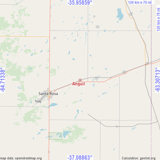
Anguil GPS coordinates[2]
36° 31' 32.412" South, 64° 0' 36.9" West
| Map corner | latitude | longitude |
|---|---|---|
| Upper-left | -35.95859°, | -64.71338° |
| Center: | -36.52567°, | -64.01025° |
| Lower-right: | -37.08863°, | -63.30713° |
| Map W x H: | 125.6×125.6 km | = 78×78mi |
| max Lat: | -21.94467° ⇑83.8% North |
| Anguil: | -36.52567° |
| min Lat: | ⇓16.2% South -54.81084° |
| min Long | Anguil | max Long |
| -72.88605° | -64.01025° | -53.64581° |
| W 38.8%⇐ | ⇒61.2% E |
Elevation
Elevation of Anguil is 159 m = 522 ft, and this is 190.3 m = 624 ft below average elevation for this country.
| Max E: |
4040 m = 13255 ft | 47.9% |
| Avg. | 349.3 m = 1146 ft | |
| Anguil | 159 m = 522 ft | |
Min E: |
-2 m = -7 ft | 52.1% |
See also: Argentina elevation on elevation.city.
Geographical zone
Anguil is located in South temperate zone (between Tropic of Capricorn and the Antarctic Circle). Distance of this Southern Tropic circle is 1455.4 km =904.3 mi to North.| Distance of | km | miles | from Anguil |
|---|---|---|---|
| Equator | 4061.3 | 2523.6 | to North |
| Tropic Capricorn | 1455.4 | 904.3 | to North |
| Antarctic Circle | 3339.9 | 2075.3 | to South |
| South Pole | 5945.8 | 3694.5 | to South |


Nearby cities:
15 places around Anguil: (largest is in red/bold)
• Ataliva Roca
61.3 km =38.1 mi,  203°
203°
• Catriló
54.3 km =33.7 mi,  75°
75°
• Colonia Barón
43.9 km =27.3 mi,  18°
18°
• Doblas
69.4 km =43.1 mi,  180°
180°
• Eduardo Castex
72.5 km =45 mi,  339°
339°
• Lonquimay
35.1 km =21.8 mi, 79°
• Macachín
74.4 km =46.2 mi,  155°
155°
• Miguel Riglos
46.4 km =28.8 mi,  141°
141°
• Pellegrini
80.9 km =50.3 mi,  69°
69°
• Quemú Quemú
65.9 km =40.9 mi,  37°
37°
• Santa Rosa
26.4 km =16.4 mi,  247°
247°
• Toay
36.8 km =22.9 mi,  243°
243°
• Trenel
92.6 km =57.5 mi,  353°
353°
• Uriburu
13.4 km =8.3 mi, 80°
• Winifreda
38.8 km =24.1 mi,  328°
328°
Sources, notices
• [Note1] Compared only with cities in Argentina existing in our database
• [Src1] Map data: © OpenStreetMap contributors (CC-BY-SA)
• [Src2] Other city data from geonames.org with taken over terms of usage.
• [Src3] Geographical zone / Annual Mean Temperature by Robert A. Rohde @ Wikipedia
