Doblas geodata
Doblas (La Pampa) is a populated place; located in Argentina in America/Argentina/Salta (GMT-3) time zone. With population of 1,860 people, there are 659 cities with bigger population in this country. Compared to other cities in Argentina, 85.8% of cities are located further ↑North; 61.3% of cities are located further →East and 52.4% of cities have lower elevation than Doblas. Note1


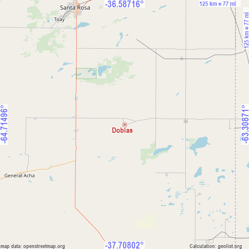
Doblas GPS coordinates[2]
37° 8' 58.812" South, 64° 0' 42.588" West
| Map corner | latitude | longitude |
|---|---|---|
| Upper-left | -36.58716°, | -64.71496° |
| Center: | -37.14967°, | -64.01183° |
| Lower-right: | -37.70802°, | -63.30871° |
| Map W x H: | 124.6×124.6 km | = 77.4×77.4mi |
| max Lat: | -21.94467° ⇑85.8% North |
| Doblas: | -37.14967° |
| min Lat: | ⇓14.2% South -54.81084° |
| min Long | Doblas | max Long |
| -72.88605° | -64.01183° | -53.64581° |
| W 38.7%⇐ | ⇒61.3% E |
Elevation
Elevation of Doblas is 161 m = 528 ft, and this is 188.3 m = 618 ft below average elevation for this country.
| Max E: |
4040 m = 13255 ft | 47.6% |
| Avg. | 349.3 m = 1146 ft | |
| Doblas | 161 m = 528 ft | |
Min E: |
-2 m = -7 ft | 52.4% |
See also: Argentina elevation on elevation.city.
Geographical zone
Doblas is located in South temperate zone (between Tropic of Capricorn and the Antarctic Circle). Distance of this Southern Tropic circle is 1524.7 km =947.4 mi to North.| Distance of | km | miles | from Doblas |
|---|---|---|---|
| Equator | 4130.7 | 2566.7 | to North |
| Tropic Capricorn | 1524.7 | 947.4 | to North |
| Antarctic Circle | 3270.5 | 2032.2 | to South |
| South Pole | 5876.4 | 3651.4 | to South |


Nearby cities:
15 places around Doblas: (largest is in red/bold)
• Alpachiri
32.9 km =20.4 mi,  140°
140°
• Anguil
69.4 km =43.1 mi,  0°
0°
• Ataliva Roca
27.5 km =17.1 mi,  298°
298°
• Bernasconi
87.2 km =54.2 mi,  164°
164°
• Catriló
98 km =60.9 mi,  32°
32°
• General Acha
58.2 km =36.2 mi,  244°
244°
• General Manuel J. Campos
51.1 km =31.8 mi,  132°
132°
• General San Martín
99 km =61.5 mi, 158°
• Guatraché
71.6 km =44.5 mi, 143°
• Lonquimay
83.5 km =51.9 mi,  24°
24°
• Macachín
30.6 km =19 mi,  87°
87°
• Miguel Riglos
43.7 km =27.2 mi,  41°
41°
• Santa Rosa
64 km =39.8 mi,  337°
337°
• Toay
62.2 km =38.6 mi,  328°
328°
• Uriburu
72.7 km =45.2 mi,  10°
10°
Sources, notices
• [Note1] Compared only with cities in Argentina existing in our database
• [Src1] Map data: © OpenStreetMap contributors (CC-BY-SA)
• [Src2] Other city data from geonames.org with taken over terms of usage.
• [Src3] Geographical zone / Annual Mean Temperature by Robert A. Rohde @ Wikipedia
