Miguel Riglos geodata
Miguel Riglos (La Pampa) is a populated place; located in Argentina in America/Argentina/Salta (GMT-3) time zone. With population of 2,385 people, there are 597 cities with bigger population in this country. Compared to other cities in Argentina, 84.8% of cities are located further ↑North; 57.5% of cities are located further →East and 50.1% of cities have lower elevation than Miguel Riglos. Note1


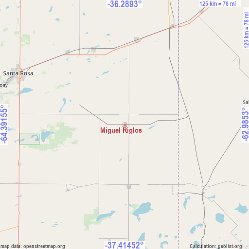
Miguel Riglos GPS coordinates[2]
36° 51' 14.328" South, 63° 41' 18.312" West
| Map corner | latitude | longitude |
|---|---|---|
| Upper-left | -36.2893°, | -64.39155° |
| Center: | -36.85398°, | -63.68842° |
| Lower-right: | -37.41452°, | -62.9853° |
| Map W x H: | 125.1×125.1 km | = 77.7×77.7mi |
| max Lat: | -21.94467° ⇑84.8% North |
| Miguel Riglos: | -36.85398° |
| min Lat: | ⇓15.2% South -54.81084° |
| min Long | Miguel Riglos | max Long |
| -72.88605° | -63.68842° | -53.64581° |
| W 42.5%⇐ | ⇒57.5% E |
Elevation
Elevation of Miguel Riglos is 144 m = 472 ft, and this is 205.3 m = 674 ft below average elevation for this country.
| Max E: |
4040 m = 13255 ft | 49.9% |
| Avg. | 349.3 m = 1146 ft | |
| Miguel Riglos | 144 m = 472 ft | |
Min E: |
-2 m = -7 ft | 50.1% |
See also: Argentina elevation on elevation.city.
Geographical zone
Miguel Riglos is located in South temperate zone (between Tropic of Capricorn and the Antarctic Circle). Distance of this Southern Tropic circle is 1491.9 km =927 mi to North.| Distance of | km | miles | from Miguel Riglos |
|---|---|---|---|
| Equator | 4097.8 | 2546.3 | to North |
| Tropic Capricorn | 1491.9 | 927 | to North |
| Antarctic Circle | 3303.4 | 2052.6 | to South |
| South Pole | 5909.3 | 3671.9 | to South |


Nearby cities:
15 places around Miguel Riglos: (largest is in red/bold)
• Alpachiri
58.7 km =36.5 mi,  187°
187°
• Anguil
46.4 km =28.8 mi,  321°
321°
• Ataliva Roca
56.5 km =35.1 mi,  249°
249°
• Catriló
55.2 km =34.3 mi,  25°
25°
• Colonia Barón
79.5 km =49.4 mi,  349°
349°
• Doblas
43.7 km =27.2 mi,  221°
221°
• General Manuel J. Campos
68 km =42.3 mi,  172°
172°
• Lonquimay
43.6 km =27.1 mi,  7°
7°
• Macachín
31.4 km =19.5 mi,  176°
176°
• Pellegrini
80.4 km =50 mi,  35°
35°
• Salliqueló
65.8 km =40.9 mi,  80°
80°
• Santa Rosa
59.2 km =36.8 mi,  296°
296°
• Toay
64.7 km =40.2 mi,  288°
288°
• Uriburu
41.6 km =25.8 mi,  338°
338°
• Winifreda
85.1 km =52.9 mi,  325°
325°
Sources, notices
• [Note1] Compared only with cities in Argentina existing in our database
• [Src1] Map data: © OpenStreetMap contributors (CC-BY-SA)
• [Src2] Other city data from geonames.org with taken over terms of usage.
• [Src3] Geographical zone / Annual Mean Temperature by Robert A. Rohde @ Wikipedia
