San Lorenzo geodata
San Lorenzo (Santa Fe) is a seat of a second-order administrative division; located in Argentina in America/Argentina/Cordoba (GMT-3) time zone. In our database, there are 785 cities with bigger population. Compared to other cities in Argentina, 59.2% of cities are located further ↑North; 62.3% of cities are located further ←West and 89.2% of cities have higher elevation than San Lorenzo. Note1


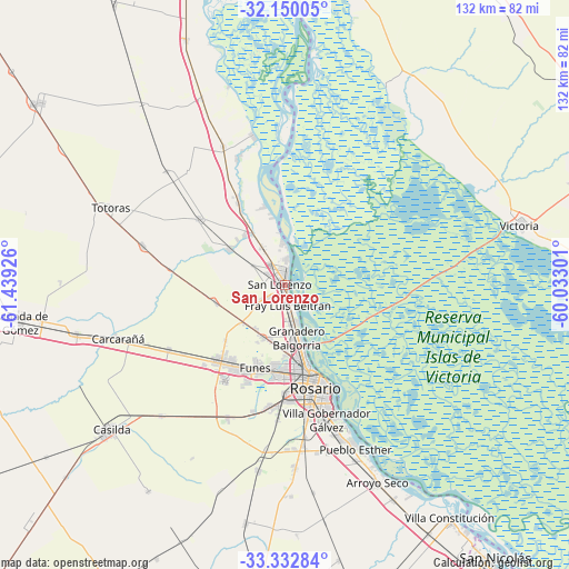
San Lorenzo GPS coordinates[2]
32° 44' 36.276" South, 60° 44' 10.068" West
| Map corner | latitude | longitude |
|---|---|---|
| Upper-left | -32.15005°, | -61.43926° |
| Center: | -32.74341°, | -60.73613° |
| Lower-right: | -33.33284°, | -60.03301° |
| Map W x H: | 131.5×131.5 km | = 81.7×81.7mi |
| max Lat: | -21.94467° ⇑59.2% North |
| San Lorenzo: | -32.74341° |
| min Lat: | ⇓40.8% South -54.81084° |
| min Long | San Lorenzo | max Long |
| -72.88605° | -60.73613° | -53.64581° |
| W 62.3%⇐ | ⇒37.7% E |
Elevation
Elevation of San Lorenzo is 30 m = 98 ft, and this is 319.3 m = 1048 ft below average elevation for this country.
| Max E: |
4040 m = 13255 ft | 89.2% |
| Avg. | 349.3 m = 1146 ft | |
| San Lorenzo | 30 m = 98 ft | |
Min E: |
-2 m = -7 ft | 10.8% |
See also: Argentina elevation on elevation.city.
Geographical zone
San Lorenzo is located in South temperate zone (between Tropic of Capricorn and the Antarctic Circle). Distance of this Southern Tropic circle is 1034.8 km =643 mi to North.| Distance of | km | miles | from San Lorenzo |
|---|---|---|---|
| Equator | 3640.7 | 2262.2 | to North |
| Tropic Capricorn | 1034.8 | 643 | to North |
| Antarctic Circle | 3760.4 | 2336.6 | to South |
| South Pole | 6366.3 | 3955.8 | to South |


Nearby cities:
15 places around San Lorenzo: (largest is in red/bold)
• Arroyo Seco
50.4 km =31.3 mi,  155°
155°
• Capitán Bermúdez
9 km =5.6 mi,  169°
169°
• Carcarañá
41 km =25.5 mi,  252°
252°
• Casilda
52.4 km =32.6 mi,  230°
230°
• Cañada de Gómez
62.1 km =38.6 mi,  262°
262°
• Fray Luis A. Beltrán
5.4 km =3.4 mi, 172°
• Funes
20.4 km =12.7 mi,  199°
199°
• Gobernador Gálvez
33.1 km =20.6 mi, 164°
• Granadero Baigorria
12.7 km =7.9 mi, 172°
• Pérez
28.5 km =17.7 mi,  185°
185°
• Roldán
23.5 km =14.6 mi,  222°
222°
• Rosario
24.4 km =15.2 mi, 158°
• Totoras
44.2 km =27.5 mi,  293°
293°
• Victoria
56.2 km =34.9 mi,  75°
75°
• Villa Constitución
65.9 km =40.9 mi,  144°
144°
Sources, notices
• [Note1] Compared only with cities in Argentina existing in our database
• [Src1] Map data: © OpenStreetMap contributors (CC-BY-SA)
• [Src2] Other city data from geonames.org with taken over terms of usage.
• [Src3] Geographical zone / Annual Mean Temperature by Robert A. Rohde @ Wikipedia
