Funes geodata
Funes (Santa Fe) is a populated place; located in Argentina in America/Argentina/Cordoba (GMT-3) time zone. With population of 14,750 people, there are 230 cities with bigger population in this country. Compared to other cities in Argentina, 61% of cities are located further ↑North; 61.9% of cities are located further ←West and 86.6% of cities have higher elevation than Funes. Note1


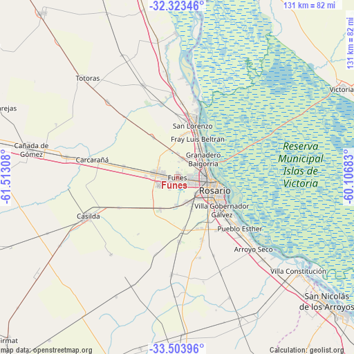
Funes GPS coordinates[2]
32° 54' 56.448" South, 60° 48' 35.82" West
| Map corner | latitude | longitude |
|---|---|---|
| Upper-left | -32.32346°, | -61.51308° |
| Center: | -32.91568°, | -60.80995° |
| Lower-right: | -33.50396°, | -60.10683° |
| Map W x H: | 131.3×131.3 km | = 81.6×81.6mi |
| max Lat: | -21.94467° ⇑61% North |
| Funes: | -32.91568° |
| min Lat: | ⇓39% South -54.81084° |
| min Long | Funes | max Long |
| -72.88605° | -60.80995° | -53.64581° |
| W 61.9%⇐ | ⇒38.1% E |
Elevation
Elevation of Funes is 36 m = 118 ft, and this is 313.3 m = 1028 ft below average elevation for this country.
| Max E: |
4040 m = 13255 ft | 86.6% |
| Avg. | 349.3 m = 1146 ft | |
| Funes | 36 m = 118 ft | |
Min E: |
-2 m = -7 ft | 13.4% |
See also: Argentina elevation on elevation.city.
Geographical zone
Funes is located in South temperate zone (between Tropic of Capricorn and the Antarctic Circle). Distance of this Southern Tropic circle is 1054 km =654.9 mi to North.| Distance of | km | miles | from Funes |
|---|---|---|---|
| Equator | 3659.9 | 2274.2 | to North |
| Tropic Capricorn | 1054 | 654.9 | to North |
| Antarctic Circle | 3741.3 | 2324.7 | to South |
| South Pole | 6347.2 | 3944 | to South |


Nearby cities:
15 places around Funes: (largest is in red/bold)
• Arroyo Seco
38.7 km =24 mi,  133°
133°
• Capitán Bermúdez
13.4 km =8.3 mi,  39°
39°
• Carcarañá
32.7 km =20.3 mi,  281°
281°
• Casilda
36.3 km =22.6 mi,  246°
246°
• Cañada de Gómez
55.7 km =34.6 mi, 281°
• Fray Luis A. Beltrán
15.8 km =9.8 mi,  28°
28°
• Gobernador Gálvez
20.3 km =12.6 mi, 128°
• Granadero Baigorria
10.8 km =6.7 mi,  52°
52°
• Pérez
10 km =6.2 mi,  156°
156°
• Roldán
9.2 km =5.7 mi, 281°
• Rosario
16.3 km =10.1 mi,  102°
102°
• San Lorenzo
20.4 km =12.7 mi,  19°
19°
• Totoras
49.8 km =30.9 mi,  317°
317°
• Villa Constitución
56.6 km =35.2 mi, 127°
• Villa Mugueta
49.6 km =30.8 mi,  207°
207°
Sources, notices
• [Note1] Compared only with cities in Argentina existing in our database
• [Src1] Map data: © OpenStreetMap contributors (CC-BY-SA)
• [Src2] Other city data from geonames.org with taken over terms of usage.
• [Src3] Geographical zone / Annual Mean Temperature by Robert A. Rohde @ Wikipedia
