Bandera geodata
Bandera (Santiago del Estero) is a seat of a second-order administrative division; located in Argentina in America/Argentina/Cordoba (GMT-3) time zone. In our database, there are 785 cities with bigger population. Compared to other cities in Argentina, 69.4% of cities are located further ↓South; 53.8% of cities are located further ←West and 63.3% of cities have higher elevation than Bandera. Note1


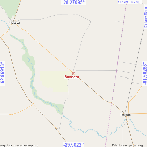
Bandera GPS coordinates[2]
28° 53' 18.24" South, 62° 15' 57.6" West
| Map corner | latitude | longitude |
|---|---|---|
| Upper-left | -28.27095°, | -62.96913° |
| Center: | -28.8884°, | -62.266° |
| Lower-right: | -29.5022°, | -61.56288° |
| Map W x H: | 136.9×136.9 km | = 85.1×85.1mi |
| max Lat: | -21.94467° ⇑30.6% North |
| Bandera: | -28.8884° |
| min Lat: | ⇓69.4% South -54.81084° |
| min Long | Bandera | max Long |
| -72.88605° | -62.266° | -53.64581° |
| W 53.8%⇐ | ⇒46.2% E |
Elevation
Elevation of Bandera is 97 m = 318 ft, and this is 252.3 m = 828 ft below average elevation for this country.
| Max E: |
4040 m = 13255 ft | 63.3% |
| Avg. | 349.3 m = 1146 ft | |
| Bandera | 97 m = 318 ft | |
Min E: |
-2 m = -7 ft | 36.7% |
See also: Argentina elevation on elevation.city.
Geographical zone
Bandera is located in South temperate zone (between Tropic of Capricorn and the Antarctic Circle). Distance of this Southern Tropic circle is 606.2 km =376.7 mi to North.| Distance of | km | miles | from Bandera |
|---|---|---|---|
| Equator | 3212.1 | 1995.9 | to North |
| Tropic Capricorn | 606.2 | 376.7 | to North |
| Antarctic Circle | 4189.1 | 2603 | to South |
| South Pole | 6795 | 4222.2 | to South |


Nearby cities:
15 places around Bandera: (largest is in red/bold)
• Añatuya
73.1 km =45.4 mi,  310°
310°
• Ceres
114.7 km =71.3 mi,  164°
164°
• Chorotis
137.4 km =85.4 mi,  38°
38°
• Colonia Dora
74 km =46 mi,  295°
295°
• Gato Colorado
142.9 km =88.8 mi,  47°
47°
• Herrera
90.4 km =56.2 mi, 300°
• Hersilia
130.7 km =81.2 mi, 161°
• Los Juríes
49.5 km =30.8 mi,  18°
18°
• Los Telares
115.6 km =71.8 mi,  264°
264°
• Quimilí
138.9 km =86.3 mi,  353°
353°
• Selva
100 km =62.1 mi,  167°
167°
• Sumampa
129.2 km =80.3 mi,  244°
244°
• Tostado
61.6 km =38.3 mi,  128°
128°
• Villa General Mitre
47.1 km =29.3 mi,  232°
232°
• Villa Unión
77.3 km =48 mi,  220°
220°
Sources, notices
• [Note1] Compared only with cities in Argentina existing in our database
• [Src1] Map data: © OpenStreetMap contributors (CC-BY-SA)
• [Src2] Other city data from geonames.org with taken over terms of usage.
• [Src3] Geographical zone / Annual Mean Temperature by Robert A. Rohde @ Wikipedia
