Selva geodata
Selva (Santiago del Estero) is a seat of a second-order administrative division; located in Argentina in America/Argentina/Cordoba (GMT-3) time zone. In our database, there are 785 cities with bigger population. Compared to other cities in Argentina, 65.8% of cities are located further ↓South; 54.8% of cities are located further ←West and 67.1% of cities have higher elevation than Selva. Note1


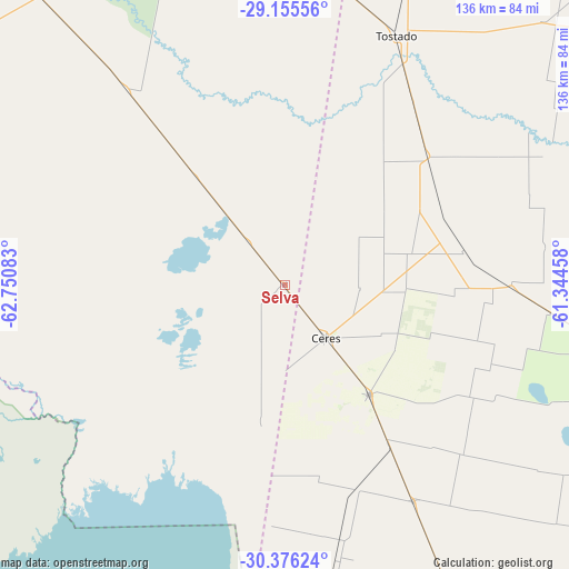
Selva GPS coordinates[2]
29° 46' 3.936" South, 62° 2' 51.72" West
| Map corner | latitude | longitude |
|---|---|---|
| Upper-left | -29.15556°, | -62.75083° |
| Center: | -29.76776°, | -62.0477° |
| Lower-right: | -30.37624°, | -61.34458° |
| Map W x H: | 135.7×135.7 km | = 84.3×84.3mi |
| max Lat: | -21.94467° ⇑34.2% North |
| Selva: | -29.76776° |
| min Lat: | ⇓65.8% South -54.81084° |
| min Long | Selva | max Long |
| -72.88605° | -62.0477° | -53.64581° |
| W 54.8%⇐ | ⇒45.2% E |
Elevation
Elevation of Selva is 88 m = 289 ft, and this is 261.3 m = 857 ft below average elevation for this country.
| Max E: |
4040 m = 13255 ft | 67.1% |
| Avg. | 349.3 m = 1146 ft | |
| Selva | 88 m = 289 ft | |
Min E: |
-2 m = -7 ft | 32.9% |
See also: Argentina elevation on elevation.city.
Geographical zone
Selva is located in South temperate zone (between Tropic of Capricorn and the Antarctic Circle). Distance of this Southern Tropic circle is 703.9 km =437.4 mi to North.| Distance of | km | miles | from Selva |
|---|---|---|---|
| Equator | 3309.9 | 2056.7 | to North |
| Tropic Capricorn | 703.9 | 437.4 | to North |
| Antarctic Circle | 4091.3 | 2542.2 | to South |
| South Pole | 6697.2 | 4161.4 | to South |


Nearby cities:
15 places around Selva: (largest is in red/bold)
• Altos de Chipión
135 km =83.9 mi,  191°
191°
• Arrufó
60.1 km =37.3 mi,  149°
149°
• Bandera
100 km =62.1 mi,  347°
347°
• Brinkmann
122.1 km =75.9 mi,  179°
179°
• Ceres
16 km =9.9 mi,  141°
141°
• Hersilia
33 km =20.5 mi, 142°
• Miramar
141.5 km =87.9 mi,  205°
205°
• Morteros
105.1 km =65.3 mi, 177°
• Porteña
138.6 km =86.1 mi, 180°
• San Cristóbal
98.6 km =61.3 mi,  127°
127°
• Sunchales
138.9 km =86.3 mi,  160°
160°
• Tostado
65.4 km =40.6 mi,  24°
24°
• Villa General Mitre
90.8 km =56.4 mi,  319°
319°
• Villa Trinidad
52.2 km =32.4 mi, 161°
• Villa Unión
81.7 km =50.8 mi,  298°
298°
Sources, notices
• [Note1] Compared only with cities in Argentina existing in our database
• [Src1] Map data: © OpenStreetMap contributors (CC-BY-SA)
• [Src2] Other city data from geonames.org with taken over terms of usage.
• [Src3] Geographical zone / Annual Mean Temperature by Robert A. Rohde @ Wikipedia
