Weiten geodata
Weiten (Lower Austria) is a seat of a third-order administrative division; located in Austria in Europe/Vienna (GMT+2) time zone. With population of 368 people, there are 2660 cities with bigger population in this country. Compared to other cities in Austria, 85.7% of cities are located further ↓South; 59% of cities are located further ←West and 66.6% of cities have higher elevation than Weiten. Note1


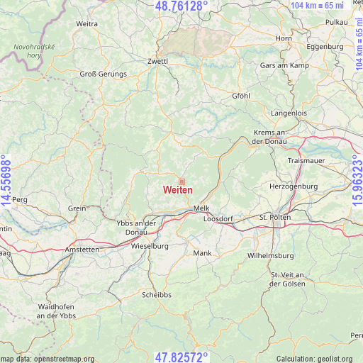
Weiten GPS coordinates[2]
48° 17' 44.304" North, 15° 15' 36.36" East
| Map corner | latitude | longitude |
|---|---|---|
| Upper-left | 48.76128°, | 14.55698° |
| Center: | 48.29564°, | 15.2601° |
| Lower-right: | 47.82572°, | 15.96323° |
| Map W x H: | 104×104 km | = 64.6×64.6mi |
| max Lat: | 48.98333° ⇑14.3% North |
| Weiten: | 48.29564° |
| min Lat: | ⇓85.7% South 46.48841° |
| min Long | Weiten | max Long |
| 9.57802° | 15.2601° | 17.1° |
| W 59%⇐ | ⇒41% E |
Elevation
Elevation of Weiten is 344 m = 1129 ft, and this is 161.5 m = 530 ft below average elevation for this country.
| Max E: |
2140 m = 7021 ft | 66.6% |
| Avg. | 505.5 m = 1658 ft | |
| Weiten | 344 m = 1129 ft | |
Min E: |
118 m = 387 ft | 33.4% |
See also: Austria elevation on elevation.city.
Geographical zone
Weiten is located in North temperate zone (between Tropic of Cancer and the Arctic Circle). Distance of this North polar circle is 2031.2 km =1262.1 mi to North.| Distance of | km | miles | from Weiten |
|---|---|---|---|
| North Pole | 4637.1 | 2881.4 | to North |
| Arctic Circle | 2031.2 | 1262.1 | to North |
| Tropic Cancer | 2764.1 | 1717.5 | to South |
| Equator | 5370 | 3336.8 | to South |


Nearby cities:
15 places around Weiten: (largest is in red/bold)
• Aggsbach
10.6 km =6.6 mi,  90°
90°
• Emmersdorf an der Donau
8.3 km =5.2 mi,  136°
136°
• Kirchschlag
11.2 km =7 mi,  345°
345°
• Klein-Pöchlarn
9.4 km =5.8 mi,  200°
200°
• Krummnußbaum an der Donauuferbahn
11.3 km =7 mi,  218°
218°
• Laimbach am Ostrong
10.9 km =6.8 mi,  282°
282°
• Leiben
5.6 km =3.5 mi,  168°
168°
• Maria Laach am Jauerling
6.3 km =3.9 mi,  81°
81°
• Maria Taferl
10.7 km =6.6 mi, 224°
• Matzleinsdorf
10.6 km =6.6 mi,  177°
177°
• Melk
9.3 km =5.8 mi,  145°
145°
• Mühldorf
10.8 km =6.7 mi,  36°
36°
• Pöchlarn
11.5 km =7.1 mi, 202°
• Pöggstall
4.8 km =3 mi,  300°
300°
• Raxendorf
5.2 km =3.2 mi,  13°
13°
Sources, notices
• [Note1] Compared only with cities in Austria existing in our database
• [Src1] Map data: © OpenStreetMap contributors (CC-BY-SA)
• [Src2] Other city data from geonames.org with taken over terms of usage.
• [Src3] Geographical zone / Annual Mean Temperature by Robert A. Rohde @ Wikipedia
