Laimbach am Ostrong geodata
Laimbach am Ostrong (Lower Austria) is a populated place; located in Austria in Europe/Vienna (GMT+2) time zone. With population of 623 people, there are 2055 cities with bigger population in this country. Compared to other cities in Austria, 86.6% of cities are located further ↓South; 56.1% of cities are located further ←West and 62.3% of cities have lower elevation than Laimbach am Ostrong. Note1
Administrative division(s):
- Level 1: Lower Austria
- Level 2: Politischer Bezirk Melk
- Level 3: Münichreith-Laimbach


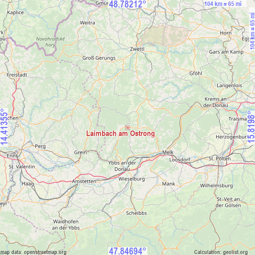
Laimbach am Ostrong GPS coordinates[2]
48° 19' 0.012" North, 15° 7' 0.012" East
| Map corner | latitude | longitude |
|---|---|---|
| Upper-left | 48.78212°, | 14.41355° |
| Center: | 48.31667°, | 15.11667° |
| Lower-right: | 47.84694°, | 15.8198° |
| Map W x H: | 104×104 km | = 64.6×64.6mi |
| max Lat: | 48.98333° ⇑13.4% North |
| Laimbach am Ostrong: | 48.31667° |
| min Lat: | ⇓86.6% South 46.48841° |
| min Long | Laimbach am Ost | max Long |
| 9.57802° | 15.11667° | 17.1° |
| W 56.1%⇐ | ⇒43.9% E |
Elevation
Elevation of Laimbach am Ostrong is 534 m = 1752 ft, and this is 28.5 m = 94 ft above average elevation for this country.
| Max E: |
2140 m = 7021 ft | 37.7% |
| Laimbach am Ostrong | 534 m 1752 ft | |
| Avg. | 505.5 m = 1658 ft | |
Min E: |
118 m = 387 ft | 62.3% |
See also: Austria elevation on elevation.city.
Geographical zone
Laimbach am Ostrong is located in North temperate zone (between Tropic of Cancer and the Arctic Circle). Distance of this North polar circle is 2028.9 km =1260.7 mi to North.| Distance of | km | miles | from Laimbach am Ostrong |
|---|---|---|---|
| North Pole | 4634.8 | 2879.9 | to North |
| Arctic Circle | 2028.9 | 1260.7 | to North |
| Tropic Cancer | 2766.4 | 1719 | to South |
| Equator | 5372.3 | 3338.2 | to South |


Nearby cities:
15 places around Laimbach am Ostrong: (largest is in red/bold)
• Bärnkopf
11.6 km =7.2 mi,  314°
314°
• Dorfstetten
10 km =6.2 mi,  275°
275°
• Gutenbrunn
5.4 km =3.4 mi,  1°
1°
• Kirchschlag
11.6 km =7.2 mi,  42°
42°
• Klein-Pöchlarn
13.4 km =8.3 mi,  146°
146°
• Krummnußbaum an der Donauuferbahn
11.7 km =7.3 mi,  162°
162°
• Krumnussbaum
12.5 km =7.8 mi, 164°
• Marbach an der Donau
11.4 km =7.1 mi,  167°
167°
• Maria Taferl
10.5 km =6.5 mi, 162°
• Martinsberg
7 km =4.3 mi,  20°
20°
• Neuda
13.4 km =8.3 mi, 158°
• Pöggstall
6.5 km =4 mi,  89°
89°
• Raxendorf
12.1 km =7.5 mi,  77°
77°
• Weiten
10.9 km =6.8 mi,  102°
102°
• Ysper
5.1 km =3.2 mi,  232°
232°
Sources, notices
• [Note1] Compared only with cities in Austria existing in our database
• [Src1] Map data: © OpenStreetMap contributors (CC-BY-SA)
• [Src2] Other city data from geonames.org with taken over terms of usage.
• [Src3] Geographical zone / Annual Mean Temperature by Robert A. Rohde @ Wikipedia
