Mühldorf geodata
Mühldorf (Lower Austria) is a seat of a third-order administrative division; located in Austria in Europe/Vienna (GMT+2) time zone. With population of 346 people, there are 2691 cities with bigger population in this country. Compared to other cities in Austria, 89.6% of cities are located further ↓South; 61.5% of cities are located further ←West and 63.4% of cities have higher elevation than Mühldorf. Note1
Administrative division(s):
- Level 1: Lower Austria
- Level 2: Politischer Bezirk Krems
- Level 3: Mühldorf


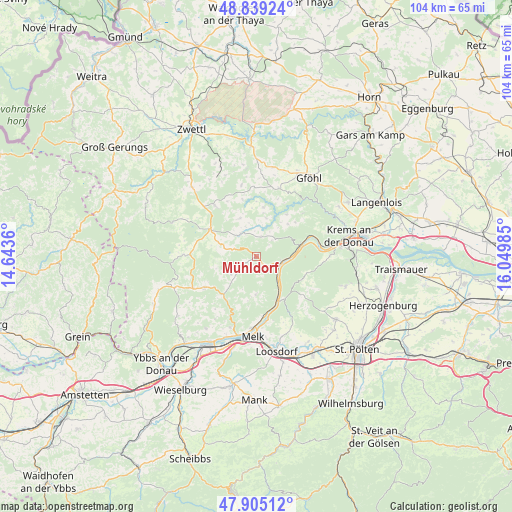
Mühldorf GPS coordinates[2]
48° 22' 27.552" North, 15° 20' 48.192" East
| Map corner | latitude | longitude |
|---|---|---|
| Upper-left | 48.83924°, | 14.6436° |
| Center: | 48.37432°, | 15.34672° |
| Lower-right: | 47.90512°, | 16.04985° |
| Map W x H: | 103.9×103.9 km | = 64.6×64.6mi |
| max Lat: | 48.98333° ⇑10.4% North |
| Mühldorf: | 48.37432° |
| min Lat: | ⇓89.6% South 46.48841° |
| min Long | Mühldorf | max Long |
| 9.57802° | 15.34672° | 17.1° |
| W 61.5%⇐ | ⇒38.5% E |
Elevation
Elevation of Mühldorf is 361 m = 1184 ft, and this is 144.5 m = 474 ft below average elevation for this country.
| Max E: |
2140 m = 7021 ft | 63.4% |
| Avg. | 505.5 m = 1658 ft | |
| Mühldorf | 361 m = 1184 ft | |
Min E: |
118 m = 387 ft | 36.6% |
See also: Austria elevation on elevation.city.
Geographical zone
Mühldorf is located in North temperate zone (between Tropic of Cancer and the Arctic Circle). Distance of this North polar circle is 2022.5 km =1256.7 mi to North.| Distance of | km | miles | from Mühldorf |
|---|---|---|---|
| North Pole | 4628.3 | 2875.9 | to North |
| Arctic Circle | 2022.5 | 1256.7 | to North |
| Tropic Cancer | 2772.8 | 1722.9 | to South |
| Equator | 5378.7 | 3342.2 | to South |


Nearby cities:
15 places around Mühldorf: (largest is in red/bold)
• Aggsbach
9.9 km =6.2 mi,  154°
154°
• Dürnstein
13 km =8.1 mi,  79°
79°
• Gansbach
12 km =7.5 mi,  129°
129°
• Gerolding
14.8 km =9.2 mi,  159°
159°
• Kirchschlag
9.4 km =5.8 mi,  283°
283°
• Maria Laach am Jauerling
7.8 km =4.8 mi,  181°
181°
• Martinsberg
14.5 km =9 mi,  270°
270°
• Ottenschlag
10.9 km =6.8 mi,  300°
300°
• Pöggstall
12.3 km =7.6 mi,  238°
238°
• Raxendorf
6.4 km =4 mi,  234°
234°
• Sallingberg
13.2 km =8.2 mi,  320°
320°
• Spitz
5.1 km =3.2 mi,  101°
101°
• Weinzierl am Walde
9 km =5.6 mi,  44°
44°
• Weiten
10.8 km =6.7 mi,  216°
216°
• Weißenkirchen in der Wachau
9.4 km =5.8 mi,  73°
73°
Sources, notices
• [Note1] Compared only with cities in Austria existing in our database
• [Src1] Map data: © OpenStreetMap contributors (CC-BY-SA)
• [Src2] Other city data from geonames.org with taken over terms of usage.
• [Src3] Geographical zone / Annual Mean Temperature by Robert A. Rohde @ Wikipedia
