Raxendorf geodata
Raxendorf (Lower Austria) is a seat of a third-order administrative division; located in Austria in Europe/Vienna (GMT+2) time zone. With population of 319 people, there are 2719 cities with bigger population in this country. Compared to other cities in Austria, 87.9% of cities are located further ↓South; 59.5% of cities are located further ←West and 59.7% of cities have lower elevation than Raxendorf. Note1
Administrative division(s):
- Level 1: Lower Austria
- Level 2: Politischer Bezirk Melk
- Level 3: Raxendorf


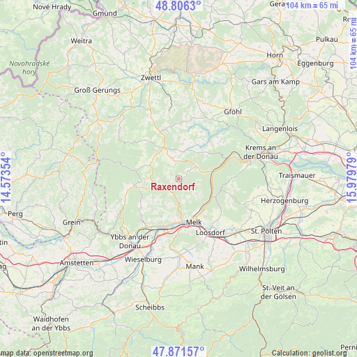
Raxendorf GPS coordinates[2]
48° 20' 27.888" North, 15° 16' 35.976" East
| Map corner | latitude | longitude |
|---|---|---|
| Upper-left | 48.8063°, | 14.57354° |
| Center: | 48.34108°, | 15.27666° |
| Lower-right: | 47.87157°, | 15.97979° |
| Map W x H: | 103.9×103.9 km | = 64.6×64.6mi |
| max Lat: | 48.98333° ⇑12.1% North |
| Raxendorf: | 48.34108° |
| min Lat: | ⇓87.9% South 46.48841° |
| min Long | Raxendorf | max Long |
| 9.57802° | 15.27666° | 17.1° |
| W 59.5%⇐ | ⇒40.5% E |
Elevation
Elevation of Raxendorf is 516 m = 1693 ft, and this is 10.5 m = 34 ft above average elevation for this country.
| Max E: |
2140 m = 7021 ft | 40.3% |
| Raxendorf | 516 m 1693 ft | |
| Avg. | 505.5 m = 1658 ft | |
Min E: |
118 m = 387 ft | 59.7% |
See also: Austria elevation on elevation.city.
Geographical zone
Raxendorf is located in North temperate zone (between Tropic of Cancer and the Arctic Circle). Distance of this North polar circle is 2026.1 km =1259 mi to North.| Distance of | km | miles | from Raxendorf |
|---|---|---|---|
| North Pole | 4632 | 2878.2 | to North |
| Arctic Circle | 2026.1 | 1259 | to North |
| Tropic Cancer | 2769.1 | 1720.6 | to South |
| Equator | 5375 | 3339.9 | to South |


Nearby cities:
15 places around Raxendorf: (largest is in red/bold)
• Aggsbach
10.8 km =6.7 mi,  119°
119°
• Emmersdorf an der Donau
12 km =7.5 mi,  157°
157°
• Gutenbrunn
12 km =7.5 mi,  282°
282°
• Kirchschlag
7.1 km =4.4 mi,  325°
325°
• Laimbach am Ostrong
12.1 km =7.5 mi,  257°
257°
• Leiben
10.5 km =6.5 mi,  180°
180°
• Maria Laach am Jauerling
6.5 km =4 mi,  129°
129°
• Martinsberg
10.1 km =6.3 mi,  292°
292°
• Melk
13.3 km =8.3 mi, 162°
• Mühldorf
6.4 km =4 mi,  54°
54°
• Ottenschlag
10.1 km =6.3 mi,  335°
335°
• Pöggstall
6 km =3.7 mi,  243°
243°
• Sallingberg
14.3 km =8.9 mi,  347°
347°
• Spitz
10.5 km =6.5 mi,  74°
74°
• Weiten
5.2 km =3.2 mi,  193°
193°
Sources, notices
• [Note1] Compared only with cities in Austria existing in our database
• [Src1] Map data: © OpenStreetMap contributors (CC-BY-SA)
• [Src2] Other city data from geonames.org with taken over terms of usage.
• [Src3] Geographical zone / Annual Mean Temperature by Robert A. Rohde @ Wikipedia
