Unken geodata
Unken (Salzburg) is a seat of a third-order administrative division; located in Austria in Europe/Vienna (GMT+2) time zone. With population of 426 people, there are 2593 cities with bigger population in this country. Compared to other cities in Austria, 51.8% of cities are located further ↓South; 85.2% of cities are located further →East and 64.2% of cities have lower elevation than Unken. Note1
Administrative division(s):
- Level 1: Salzburg
- Level 2: Politischer Bezirk Zell am See
- Level 3: Unken


Unken GPS coordinates[2]
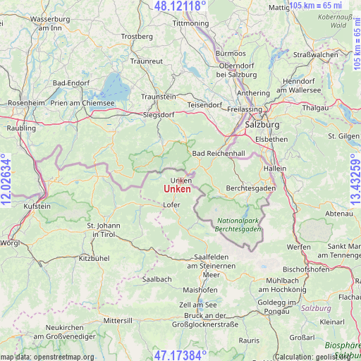
47° 38' 58.776" North, 12° 43' 46.056" East
| Map corner | latitude | longitude |
|---|---|---|
| Upper-left | 48.12118°, | 12.02634° |
| Center: | 47.64966°, | 12.72946° |
| Lower-right: | 47.17384°, | 13.43259° |
| Map W x H: | 105.3×105.3 km | = 65.4×65.4mi |
| max Lat: | 48.98333° ⇑48.2% North |
| Unken: | 47.64966° |
| min Lat: | ⇓51.8% South 46.48841° |
| min Long | Unken | max Long |
| 9.57802° | 12.72946° | 17.1° |
| W 14.8%⇐ | ⇒85.2% E |
Elevation
Elevation of Unken is 546 m = 1791 ft, and this is 40.5 m = 133 ft above average elevation for this country.
| Max E: |
2140 m = 7021 ft | 35.8% |
| Unken | 546 m 1791 ft | |
| Avg. | 505.5 m = 1658 ft | |
Min E: |
118 m = 387 ft | 64.2% |
See also: Austria elevation on elevation.city.
Geographical zone
Unken is located in North temperate zone (between Tropic of Cancer and the Arctic Circle). Distance of this North polar circle is 2103 km =1306.7 mi to North.| Distance of | km | miles | from Unken |
|---|---|---|---|
| North Pole | 4708.9 | 2926 | to North |
| Arctic Circle | 2103 | 1306.7 | to North |
| Tropic Cancer | 2692.2 | 1672.9 | to South |
| Equator | 5298.1 | 3292.1 | to South |


Nearby cities:
15 places around Unken: (largest is in red/bold)
• Erpfendorf
21 km =13 mi,  249°
249°
• Glanegg
23.1 km =14.4 mi,  61°
61°
• Gois
22 km =13.7 mi,  53°
53°
• Grossgmain
15.8 km =9.8 mi, 58°
• Hochfilzen
22 km =13.7 mi,  202°
202°
• Käferheim
22.2 km =13.8 mi, 47°
• Lofer
7.7 km =4.8 mi, 200°
• Niederland
1.9 km =1.2 mi,  8°
8°
• Sankt Jakob in Haus
21.4 km =13.3 mi,  218°
218°
• Sankt Martin bei Lofer
9.5 km =5.9 mi,  193°
193°
• Sankt Ulrich am Pillersee
18 km =11.2 mi, 220°
• Sonnberg
22.2 km =13.8 mi,  179°
179°
• Waidring
14.3 km =8.9 mi,  238°
238°
• Wals
23.1 km =14.4 mi, 50°
• Walserberg
22 km =13.7 mi, 51°
Sources, notices
• [Note1] Compared only with cities in Austria existing in our database
• [Src1] Map data: © OpenStreetMap contributors (CC-BY-SA)
• [Src2] Other city data from geonames.org with taken over terms of usage.
• [Src3] Geographical zone / Annual Mean Temperature by Robert A. Rohde @ Wikipedia
