Piberegg geodata
Piberegg (Styria) is a seat of a third-order administrative division; located in Austria in Europe/Vienna (GMT+2) time zone. With population of 174 people, there are 2874 cities with bigger population in this country. Compared to other cities in Austria, 79.5% of cities are located further ↑North; 56% of cities are located further ←West and 53% of cities have lower elevation than Piberegg. Note1


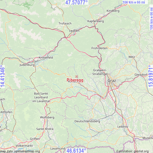
Piberegg GPS coordinates[2]
47° 5' 39.264" North, 15° 6' 59.688" East
| Map corner | latitude | longitude |
|---|---|---|
| Upper-left | 47.57077°, | 14.41346° |
| Center: | 47.09424°, | 15.11658° |
| Lower-right: | 46.6134°, | 15.81971° |
| Map W x H: | 106.4×106.4 km | = 66.1×66.1mi |
| max Lat: | 48.98333° ⇑79.5% North |
| Piberegg: | 47.09424° |
| min Lat: | ⇓20.5% South 46.48841° |
| min Long | Piberegg | max Long |
| 9.57802° | 15.11658° | 17.1° |
| W 56%⇐ | ⇒44% E |
Elevation
Elevation of Piberegg is 472 m = 1549 ft, and this is 33.5 m = 110 ft below average elevation for this country.
| Max E: |
2140 m = 7021 ft | 47% |
| Avg. | 505.5 m = 1658 ft | |
| Piberegg | 472 m = 1549 ft | |
Min E: |
118 m = 387 ft | 53% |
See also: Austria elevation on elevation.city.
Geographical zone
Piberegg is located in North temperate zone (between Tropic of Cancer and the Arctic Circle). Distance of this North polar circle is 2164.8 km =1345.1 mi to North.| Distance of | km | miles | from Piberegg |
|---|---|---|---|
| North Pole | 4770.7 | 2964.4 | to North |
| Arctic Circle | 2164.8 | 1345.1 | to North |
| Tropic Cancer | 2630.5 | 1634.5 | to South |
| Equator | 5236.4 | 3253.7 | to South |


Nearby cities:
15 places around Piberegg: (largest is in red/bold)
• Bärnbach
2.7 km =1.7 mi,  161°
161°
• Edelschrott
9.4 km =5.8 mi,  210°
210°
• Geistthal
8.9 km =5.5 mi,  25°
25°
• Gradenberg
3.9 km =2.4 mi,  242°
242°
• Hochtregist
1.4 km =0.9 mi,  63°
63°
• Kainach bei Voitsberg
5 km =3.1 mi,  341°
341°
• Kohlschwarz
2.5 km =1.6 mi,  0°
0°
• Köflach
4 km =2.5 mi,  219°
219°
• Maria Lankowitz
5.3 km =3.3 mi,  227°
227°
• Pichling bei Köflach
6.2 km =3.9 mi, 213°
• Rosental an der Kainach
4.7 km =2.9 mi,  175°
175°
• Stallhofen
9 km =5.6 mi,  122°
122°
• Stiwoll
7.6 km =4.7 mi,  85°
85°
• Södingberg
4.4 km =2.7 mi,  71°
71°
• Voitsberg
6.2 km =3.9 mi,  153°
153°
Sources, notices
• [Note1] Compared only with cities in Austria existing in our database
• [Src1] Map data: © OpenStreetMap contributors (CC-BY-SA)
• [Src2] Other city data from geonames.org with taken over terms of usage.
• [Src3] Geographical zone / Annual Mean Temperature by Robert A. Rohde @ Wikipedia
