Kohlschwarz geodata
Kohlschwarz (Styria) is a seat of a third-order administrative division; located in Austria in Europe/Vienna (GMT+2) time zone. With population of 253 people, there are 2807 cities with bigger population in this country. Compared to other cities in Austria, 78.3% of cities are located further ↑North; 56.1% of cities are located further ←West and 68.3% of cities have lower elevation than Kohlschwarz. Note1
Administrative division(s):
- Level 1: Styria
- Level 2: Politischer Bezirk Voitsberg
- Level 3: Kainach bei Voitsberg


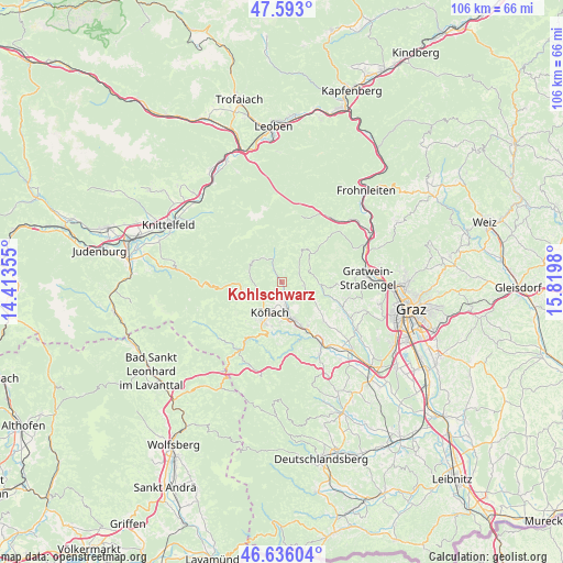
Kohlschwarz GPS coordinates[2]
47° 7' 0.012" North, 15° 7' 0.012" East
| Map corner | latitude | longitude |
|---|---|---|
| Upper-left | 47.593°, | 14.41355° |
| Center: | 47.11667°, | 15.11667° |
| Lower-right: | 46.63604°, | 15.8198° |
| Map W x H: | 106.4×106.4 km | = 66.1×66.1mi |
| max Lat: | 48.98333° ⇑78.3% North |
| Kohlschwarz: | 47.11667° |
| min Lat: | ⇓21.7% South 46.48841° |
| min Long | Kohlschwarz | max Long |
| 9.57802° | 15.11667° | 17.1° |
| W 56.1%⇐ | ⇒43.9% E |
Elevation
Elevation of Kohlschwarz is 573 m = 1880 ft, and this is 67.5 m = 221 ft above average elevation for this country.
| Max E: |
2140 m = 7021 ft | 31.7% |
| Kohlschwarz | 573 m 1880 ft | |
| Avg. | 505.5 m = 1658 ft | |
Min E: |
118 m = 387 ft | 68.3% |
See also: Austria elevation on elevation.city.
Geographical zone
Kohlschwarz is located in North temperate zone (between Tropic of Cancer and the Arctic Circle). Distance of this North polar circle is 2162.3 km =1343.6 mi to North.| Distance of | km | miles | from Kohlschwarz |
|---|---|---|---|
| North Pole | 4768.2 | 2962.8 | to North |
| Arctic Circle | 2162.3 | 1343.6 | to North |
| Tropic Cancer | 2633 | 1636.1 | to South |
| Equator | 5238.9 | 3255.3 | to South |


Nearby cities:
15 places around Kohlschwarz: (largest is in red/bold)
• Bärnbach
5.1 km =3.2 mi,  170°
170°
• Gallmannsegg
8.3 km =5.2 mi,  332°
332°
• Geistthal
6.7 km =4.2 mi,  34°
34°
• Gradenberg
5.5 km =3.4 mi,  218°
218°
• Hochtregist
2.2 km =1.4 mi,  145°
145°
• Kainach bei Voitsberg
2.7 km =1.7 mi,  323°
323°
• Köflach
6.1 km =3.8 mi,  204°
204°
• Maria Lankowitz
7.2 km =4.5 mi,  212°
212°
• Piberegg
2.5 km =1.6 mi,  180°
180°
• Pichling bei Köflach
8.4 km =5.2 mi, 204°
• Rosental an der Kainach
7.2 km =4.5 mi, 176°
• Stallhofen
10.6 km =6.6 mi,  134°
134°
• Stiwoll
7.8 km =4.8 mi,  103°
103°
• Södingberg
4.3 km =2.7 mi, 104°
• Voitsberg
8.5 km =5.3 mi,  161°
161°
Sources, notices
• [Note1] Compared only with cities in Austria existing in our database
• [Src1] Map data: © OpenStreetMap contributors (CC-BY-SA)
• [Src2] Other city data from geonames.org with taken over terms of usage.
• [Src3] Geographical zone / Annual Mean Temperature by Robert A. Rohde @ Wikipedia
