Niederneukirchen geodata
Niederneukirchen (Upper Austria) is a populated place; located in Austria in Europe/Vienna (GMT+2) time zone. With population of 1,083 people, there are 1182 cities with bigger population in this country. Compared to other cities in Austria, 76.4% of cities are located further ↓South; 57% of cities are located further →East and 69.1% of cities have higher elevation than Niederneukirchen. Note1
Administrative division(s):
- Level 1: Upper Austria
- Level 2: Politischer Bezirk Linz-Land
- Level 3: Niederneukirchen


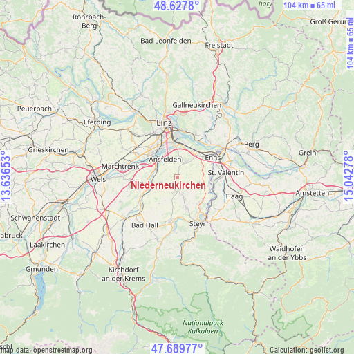
Niederneukirchen GPS coordinates[2]
48° 9' 39.348" North, 14° 20' 22.74" East
| Map corner | latitude | longitude |
|---|---|---|
| Upper-left | 48.6278°, | 13.63653° |
| Center: | 48.16093°, | 14.33965° |
| Lower-right: | 47.68977°, | 15.04278° |
| Map W x H: | 104.3×104.3 km | = 64.8×64.8mi |
| max Lat: | 48.98333° ⇑23.6% North |
| Niederneukirchen: | 48.16093° |
| min Lat: | ⇓76.4% South 46.48841° |
| min Long | Niederneukirche | max Long |
| 9.57802° | 14.33965° | 17.1° |
| W 43%⇐ | ⇒57% E |
Elevation
Elevation of Niederneukirchen is 333 m = 1093 ft, and this is 172.5 m = 566 ft below average elevation for this country.
| Max E: |
2140 m = 7021 ft | 69.1% |
| Avg. | 505.5 m = 1658 ft | |
| Niederneukirchen | 333 m = 1093 ft | |
Min E: |
118 m = 387 ft | 30.9% |
See also: Austria elevation on elevation.city.
Geographical zone
Niederneukirchen is located in North temperate zone (between Tropic of Cancer and the Arctic Circle). Distance of this North polar circle is 2046.2 km =1271.4 mi to North.| Distance of | km | miles | from Niederneukirchen |
|---|---|---|---|
| North Pole | 4652.1 | 2890.7 | to North |
| Arctic Circle | 2046.2 | 1271.4 | to North |
| Tropic Cancer | 2749.1 | 1708.2 | to South |
| Equator | 5355 | 3327.4 | to South |


Nearby cities:
15 places around Niederneukirchen: (largest is in red/bold)
• Ansfelden
6.6 km =4.1 mi,  325°
325°
• Asten
8.7 km =5.4 mi,  41°
41°
• Audorf
7.8 km =4.8 mi,  324°
324°
• Freindorf
7.9 km =4.9 mi,  335°
335°
• Haid
8.2 km =5.1 mi,  306°
306°
• Hofkirchen im Traunkreis
3.5 km =2.2 mi,  125°
125°
• Kremsdorf
7.2 km =4.5 mi, 307°
• Losensteinleithen
5.2 km =3.2 mi,  165°
165°
• Nöstlbach
7 km =4.3 mi,  275°
275°
• Rapperswinkel
8.2 km =5.1 mi, 315°
• Rohrbach
6.2 km =3.9 mi,  7°
7°
• Sankt Florian
5.7 km =3.5 mi,  29°
29°
• Sankt Marien
4.8 km =3 mi,  252°
252°
• Weichstetten
4.7 km =2.9 mi,  197°
197°
• Weifersdorf
8.7 km =5.4 mi,  244°
244°
Sources, notices
• [Note1] Compared only with cities in Austria existing in our database
• [Src1] Map data: © OpenStreetMap contributors (CC-BY-SA)
• [Src2] Other city data from geonames.org with taken over terms of usage.
• [Src3] Geographical zone / Annual Mean Temperature by Robert A. Rohde @ Wikipedia
