Flattach geodata
Flattach (Carinthia) is a seat of a third-order administrative division; located in Austria in Europe/Vienna (GMT+2) time zone. With population of 396 people, there are 2620 cities with bigger population in this country. Compared to other cities in Austria, 86.9% of cities are located further ↑North; 80.5% of cities are located further →East and 86% of cities have lower elevation than Flattach. Note1
Administrative division(s):
- Level 1: Carinthia
- Level 2: Politischer Bezirk Spittal an der Drau
- Level 3: Flattach


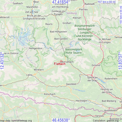
Flattach GPS coordinates[2]
46° 56' 18.996" North, 13° 8' 3.984" East
| Map corner | latitude | longitude |
|---|---|---|
| Upper-left | 47.41654°, | 12.43132° |
| Center: | 46.93861°, | 13.13444° |
| Lower-right: | 46.45638°, | 13.83757° |
| Map W x H: | 106.8×106.8 km | = 66.4×66.4mi |
| max Lat: | 48.98333° ⇑86.9% North |
| Flattach: | 46.93861° |
| min Lat: | ⇓13.1% South 46.48841° |
| min Long | Flattach | max Long |
| 9.57802° | 13.13444° | 17.1° |
| W 19.5%⇐ | ⇒80.5% E |
Elevation
Elevation of Flattach is 814 m = 2671 ft, and this is 308.5 m = 1012 ft above average elevation for this country.
| Max E: |
2140 m = 7021 ft | 14% |
| Flattach | 814 m 2671 ft | |
| Avg. | 505.5 m = 1658 ft | |
Min E: |
118 m = 387 ft | 86% |
See also: Austria elevation on elevation.city.
Geographical zone
Flattach is located in North temperate zone (between Tropic of Cancer and the Arctic Circle). Distance of this North polar circle is 2182.1 km =1355.9 mi to North.| Distance of | km | miles | from Flattach |
|---|---|---|---|
| North Pole | 4788 | 2975.1 | to North |
| Arctic Circle | 2182.1 | 1355.9 | to North |
| Tropic Cancer | 2613.2 | 1623.8 | to South |
| Equator | 5219.1 | 3243 | to South |


Nearby cities:
15 places around Flattach: (largest is in red/bold)
• Bad Gastein
19.7 km =12.2 mi,  0°
0°
• Berg
21.1 km =13.1 mi,  180°
180°
• Berg im Drautal
21.1 km =13.1 mi, 179°
• Greifenburg
21.2 km =13.2 mi,  170°
170°
• Großkirchheim
18.5 km =11.5 mi,  281°
281°
• Irschen
21.8 km =13.5 mi,  202°
202°
• Möllbrücke
21.4 km =13.3 mi,  122°
122°
• Mörtschach
16.5 km =10.3 mi,  264°
264°
• Mühldorf
18.8 km =11.7 mi, 117°
• Obervellach
5.3 km =3.3 mi,  92°
92°
• Rangersdorf
16.6 km =10.3 mi,  238°
238°
• Sachsenburg
20.7 km =12.9 mi,  125°
125°
• Stall
9.1 km =5.7 mi,  234°
234°
• Steinfeld
21.9 km =13.6 mi,  156°
156°
• Winklern
21 km =13 mi,  249°
249°
Sources, notices
• [Note1] Compared only with cities in Austria existing in our database
• [Src1] Map data: © OpenStreetMap contributors (CC-BY-SA)
• [Src2] Other city data from geonames.org with taken over terms of usage.
• [Src3] Geographical zone / Annual Mean Temperature by Robert A. Rohde @ Wikipedia
