Heiligenblut geodata
Heiligenblut (Carinthia) is a seat of a third-order administrative division; located in Austria in Europe/Vienna (GMT+2) time zone. With population of 1,069 people, there are 1196 cities with bigger population in this country. Compared to other cities in Austria, 82.5% of cities are located further ↑North; 84.2% of cities are located further →East and 98.8% of cities have lower elevation than Heiligenblut. Note1
Administrative division(s):
- Level 1: Carinthia
- Level 2: Politischer Bezirk Spittal an der Drau
- Level 3: Heiligenblut


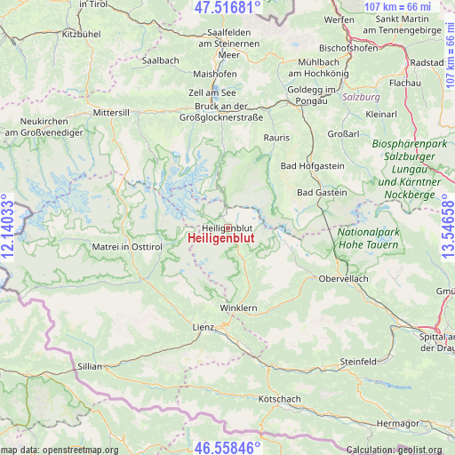
Heiligenblut GPS coordinates[2]
47° 2' 23.244" North, 12° 50' 36.42" East
| Map corner | latitude | longitude |
|---|---|---|
| Upper-left | 47.51681°, | 12.14033° |
| Center: | 47.03979°, | 12.84345° |
| Lower-right: | 46.55846°, | 13.54658° |
| Map W x H: | 106.6×106.6 km | = 66.2×66.2mi |
| max Lat: | 48.98333° ⇑82.5% North |
| Heiligenblut: | 47.03979° |
| min Lat: | ⇓17.5% South 46.48841° |
| min Long | Heiligenblut | max Long |
| 9.57802° | 12.84345° | 17.1° |
| W 15.8%⇐ | ⇒84.2% E |
Elevation
Elevation of Heiligenblut is 1316 m = 4318 ft, and this is 810.5 m = 2659 ft above average elevation for this country.
| Max E: |
2140 m = 7021 ft | 1.2% |
| Heiligenblut | 1316 m 4318 ft | |
| Avg. | 505.5 m = 1658 ft | |
Min E: |
118 m = 387 ft | 98.8% |
See also: Austria elevation on elevation.city.
Geographical zone
Heiligenblut is located in North temperate zone (between Tropic of Cancer and the Arctic Circle). Distance of this North polar circle is 2170.8 km =1348.9 mi to North.| Distance of | km | miles | from Heiligenblut |
|---|---|---|---|
| North Pole | 4776.7 | 2968.1 | to North |
| Arctic Circle | 2170.8 | 1348.9 | to North |
| Tropic Cancer | 2624.4 | 1630.7 | to South |
| Equator | 5230.3 | 3250 | to South |


Nearby cities:
15 places around Heiligenblut: (largest is in red/bold)
• Ainet
22.6 km =14 mi,  211°
211°
• Debant
23 km =14.3 mi,  185°
185°
• Dölsach
23.5 km =14.6 mi,  179°
179°
• Großkirchheim
8.5 km =5.3 mi,  151°
151°
• Kals am Großglockner
15.6 km =9.7 mi,  254°
254°
• Mörtschach
14.1 km =8.8 mi,  156°
156°
• Nußdorf
23.2 km =14.4 mi, 188°
• Oberlienz
23 km =14.3 mi,  201°
201°
• Rangersdorf
21.5 km =13.4 mi, 158°
• Schlaiten
22.9 km =14.2 mi,  218°
218°
• Stall
22.2 km =13.8 mi,  138°
138°
• Thurn
21.8 km =13.5 mi, 195°
• Vorderschneeberg
23.2 km =14.4 mi,  59°
59°
• Winklern
18.6 km =11.6 mi,  172°
172°
• Wörtherberg
21.8 km =13.5 mi,  29°
29°
In other languages:
- In German: Heiligenblut, Heiligenblut am Großglockner
- In Russian: Хайлигенблют, Хайлигенблут
- In Chinese: 海利根布卢特
Sources, notices
• [Note1] Compared only with cities in Austria existing in our database
• [Src1] Map data: © OpenStreetMap contributors (CC-BY-SA)
• [Src2] Other city data from geonames.org with taken over terms of usage.
• [Src3] Geographical zone / Annual Mean Temperature by Robert A. Rohde @ Wikipedia
