Bärnkopf geodata
Bärnkopf (Lower Austria) is a seat of a third-order administrative division; located in Austria in Europe/Vienna (GMT+2) time zone. With population of 355 people, there are 2678 cities with bigger population in this country. Compared to other cities in Austria, 90.3% of cities are located further ↓South; 54.3% of cities are located further ←West and 93.1% of cities have lower elevation than Bärnkopf. Note1
Administrative division(s):
- Level 1: Lower Austria
- Level 2: Politischer Bezirk Zwettl
- Level 3: Bärnkopf


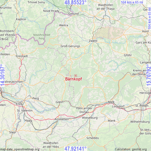
Bärnkopf GPS coordinates[2]
48° 23' 25.656" North, 15° 0' 17.244" East
| Map corner | latitude | longitude |
|---|---|---|
| Upper-left | 48.85523°, | 14.30167° |
| Center: | 48.39046°, | 15.00479° |
| Lower-right: | 47.92141°, | 15.70792° |
| Map W x H: | 103.8×103.8 km | = 64.5×64.5mi |
| max Lat: | 48.98333° ⇑9.7% North |
| Bärnkopf: | 48.39046° |
| min Lat: | ⇓90.3% South 46.48841° |
| min Long | Bärnkopf | max Long |
| 9.57802° | 15.00479° | 17.1° |
| W 54.3%⇐ | ⇒45.7% E |
Elevation
Elevation of Bärnkopf is 964 m = 3163 ft, and this is 458.5 m = 1504 ft above average elevation for this country.
| Max E: |
2140 m = 7021 ft | 6.9% |
| Bärnkopf | 964 m 3163 ft | |
| Avg. | 505.5 m = 1658 ft | |
Min E: |
118 m = 387 ft | 93.1% |
See also: Austria elevation on elevation.city.
Geographical zone
Bärnkopf is located in North temperate zone (between Tropic of Cancer and the Arctic Circle). Distance of this North polar circle is 2020.7 km =1255.6 mi to North.| Distance of | km | miles | from Bärnkopf |
|---|---|---|---|
| North Pole | 4626.5 | 2874.8 | to North |
| Arctic Circle | 2020.7 | 1255.6 | to North |
| Tropic Cancer | 2774.6 | 1724.1 | to South |
| Equator | 5380.5 | 3343.3 | to South |


Nearby cities:
15 places around Bärnkopf: (largest is in red/bold)
• Altmelon
8.5 km =5.3 mi,  340°
340°
• Arbesbach
12.1 km =7.5 mi, 341°
• Bad Traunstein
9.9 km =6.2 mi,  57°
57°
• Dorfstetten
7.4 km =4.6 mi,  193°
193°
• Gutenbrunn
8.9 km =5.5 mi,  108°
108°
• Königswiesen
12.4 km =7.7 mi,  277°
277°
• Laimbach am Ostrong
11.6 km =7.2 mi,  134°
134°
• Martinsberg
10.8 km =6.7 mi,  98°
98°
• Mönchdorf
15.9 km =9.9 mi,  257°
257°
• Pabneukirchen
15.7 km =9.8 mi,  241°
241°
• Rappottenstein
15.6 km =9.7 mi,  20°
20°
• Sankt Georgen am Walde
8.3 km =5.2 mi,  245°
245°
• Schönbach
6.9 km =4.3 mi, 17°
• Waldhausen im Strudengau
13.6 km =8.5 mi,  198°
198°
• Ysper
12.1 km =7.5 mi,  159°
159°
Sources, notices
• [Note1] Compared only with cities in Austria existing in our database
• [Src1] Map data: © OpenStreetMap contributors (CC-BY-SA)
• [Src2] Other city data from geonames.org with taken over terms of usage.
• [Src3] Geographical zone / Annual Mean Temperature by Robert A. Rohde @ Wikipedia
