Haag geodata
Haag (Lower Austria) is a seat of a third-order administrative division; located in Austria in Europe/Vienna (GMT+2) time zone. With population of 2,777 people, there are 419 cities with bigger population in this country. Compared to other cities in Austria, 73.4% of cities are located further ↓South; 52.2% of cities are located further →East and 70.9% of cities have higher elevation than Haag. Note1
Administrative division(s):
- Level 1: Lower Austria
- Level 2: Politischer Bezirk Amstetten
- Level 3: Haag


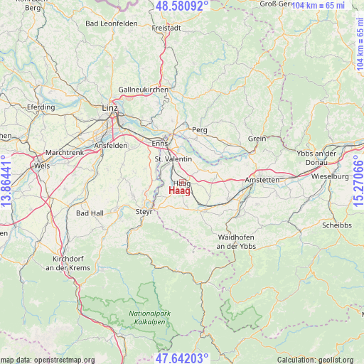
Haag GPS coordinates[2]
48° 6' 49.032" North, 14° 34' 3.108" East
| Map corner | latitude | longitude |
|---|---|---|
| Upper-left | 48.58092°, | 13.86441° |
| Center: | 48.11362°, | 14.56753° |
| Lower-right: | 47.64203°, | 15.27066° |
| Map W x H: | 104.4×104.4 km | = 64.9×64.9mi |
| max Lat: | 48.98333° ⇑26.6% North |
| Haag: | 48.11362° |
| min Lat: | ⇓73.4% South 46.48841° |
| min Long | Haag | max Long |
| 9.57802° | 14.56753° | 17.1° |
| W 47.8%⇐ | ⇒52.2% E |
Elevation
Elevation of Haag is 323 m = 1060 ft, and this is 182.5 m = 599 ft below average elevation for this country.
| Max E: |
2140 m = 7021 ft | 70.9% |
| Avg. | 505.5 m = 1658 ft | |
| Haag | 323 m = 1060 ft | |
Min E: |
118 m = 387 ft | 29.1% |
See also: Austria elevation on elevation.city.
Geographical zone
Haag is located in North temperate zone (between Tropic of Cancer and the Arctic Circle). Distance of this North polar circle is 2051.4 km =1274.7 mi to North.| Distance of | km | miles | from Haag |
|---|---|---|---|
| North Pole | 4657.3 | 2893.9 | to North |
| Arctic Circle | 2051.4 | 1274.7 | to North |
| Tropic Cancer | 2743.8 | 1704.9 | to South |
| Equator | 5349.7 | 3324.1 | to South |


Nearby cities:
15 places around Haag: (largest is in red/bold)
• Edelhof
0.7 km =0.4 mi,  307°
307°
• Erla
9.5 km =5.9 mi,  1°
1°
• Ernsthofen
6.7 km =4.2 mi,  284°
284°
• Haidershofen
8.9 km =5.5 mi,  241°
241°
• Kronstorf
8.4 km =5.2 mi,  293°
293°
• Limbach
7.8 km =4.8 mi,  58°
58°
• Sankt Johann in Engstetten
5.7 km =3.5 mi,  140°
140°
• Sankt Peter in der Au Dorf
8.6 km =5.3 mi, 140°
• Sankt Peter in der Au Markt
8.7 km =5.4 mi,  152°
152°
• Sankt Valentin
7 km =4.3 mi,  327°
327°
• Strengberg
7.2 km =4.5 mi, 59°
• Thaling
9.9 km =6.2 mi, 313°
• Wanzenöd
9.8 km =6.1 mi,  223°
223°
• Weistrach
7.2 km =4.5 mi,  170°
170°
• Wolfsbach
9 km =5.6 mi,  125°
125°
Sources, notices
• [Note1] Compared only with cities in Austria existing in our database
• [Src1] Map data: © OpenStreetMap contributors (CC-BY-SA)
• [Src2] Other city data from geonames.org with taken over terms of usage.
• [Src3] Geographical zone / Annual Mean Temperature by Robert A. Rohde @ Wikipedia
