Gföhl geodata
Gföhl (Lower Austria) is a seat of a third-order administrative division; located in Austria in Europe/Vienna (GMT+2) time zone. With population of 2,125 people, there are 573 cities with bigger population in this country. Compared to other cities in Austria, 94.6% of cities are located further ↓South; 64.9% of cities are located further ←West and 66.2% of cities have lower elevation than Gföhl. Note1


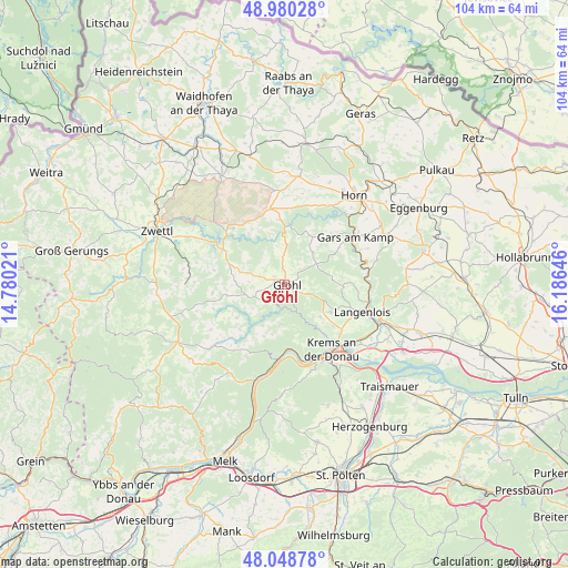
Gföhl GPS coordinates[2]
48° 31' 0.012" North, 15° 28' 59.988" East
| Map corner | latitude | longitude |
|---|---|---|
| Upper-left | 48.98028°, | 14.78021° |
| Center: | 48.51667°, | 15.48333° |
| Lower-right: | 48.04878°, | 16.18646° |
| Map W x H: | 103.6×103.6 km | = 64.4×64.4mi |
| max Lat: | 48.98333° ⇑5.4% North |
| Gföhl: | 48.51667° |
| min Lat: | ⇓94.6% South 46.48841° |
| min Long | Gföhl | max Long |
| 9.57802° | 15.48333° | 17.1° |
| W 64.9%⇐ | ⇒35.1% E |
Elevation
Elevation of Gföhl is 560 m = 1837 ft, and this is 54.5 m = 179 ft above average elevation for this country.
| Max E: |
2140 m = 7021 ft | 33.8% |
| Gföhl | 560 m 1837 ft | |
| Avg. | 505.5 m = 1658 ft | |
Min E: |
118 m = 387 ft | 66.2% |
See also: Austria elevation on elevation.city.
Geographical zone
Gföhl is located in North temperate zone (between Tropic of Cancer and the Arctic Circle). Distance of this North polar circle is 2006.6 km =1246.8 mi to North.| Distance of | km | miles | from Gföhl |
|---|---|---|---|
| North Pole | 4612.5 | 2866.1 | to North |
| Arctic Circle | 2006.6 | 1246.8 | to North |
| Tropic Cancer | 2788.6 | 1732.8 | to South |
| Equator | 5394.5 | 3352 | to South |


Nearby cities:
15 places around Gföhl: (largest is in red/bold)
• Droß
9 km =5.6 mi,  130°
130°
• Egelsee
12.5 km =7.8 mi,  152°
152°
• Imbach
10.5 km =6.5 mi,  135°
135°
• Jaidhof
1.9 km =1.2 mi,  0°
0°
• Krumau am Kamp
8.4 km =5.2 mi,  342°
342°
• Lengenfeld
9.9 km =6.2 mi,  120°
120°
• Rastenfeld
12.8 km =8 mi,  299°
299°
• Rehberg
12.2 km =7.6 mi, 141°
• Sankt Leonhard am Hornerwald
10 km =6.2 mi,  21°
21°
• Schiltern
9.8 km =6.1 mi,  90°
90°
• Senftenberg
10.5 km =6.5 mi, 152°
• Stratzing
11.4 km =7.1 mi, 130°
• Weinzierl am Walde
10.1 km =6.3 mi,  201°
201°
• Weißenkirchen in der Wachau
13.2 km =8.2 mi,  184°
184°
• Wolfshoferamt
11.1 km =6.9 mi,  33°
33°
Sources, notices
• [Note1] Compared only with cities in Austria existing in our database
• [Src1] Map data: © OpenStreetMap contributors (CC-BY-SA)
• [Src2] Other city data from geonames.org with taken over terms of usage.
• [Src3] Geographical zone / Annual Mean Temperature by Robert A. Rohde @ Wikipedia
