Sitzendorf an der Schmida geodata
Sitzendorf an der Schmida (Lower Austria) is a seat of a third-order administrative division; located in Austria in Europe/Vienna (GMT+2) time zone. With population of 622 people, there are 2059 cities with bigger population in this country. Compared to other cities in Austria, 96.5% of cities are located further ↓South; 78.6% of cities are located further ←West and 86.2% of cities have higher elevation than Sitzendorf an der Schmida. Note1
Administrative division(s):
- Level 1: Lower Austria
- Level 2: Politischer Bezirk Hollabrunn
- Level 3: Sitzendorf an der Schmida
Current local time in Sitzendorf an der Schmida:
10:42 PM, FridayDifference from your time zone: hours


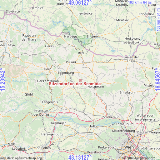
Sitzendorf an der Schmida GPS coordinates[2]
48° 35' 54.276" North, 15° 56' 33.144" East
| Map corner | latitude | longitude |
|---|---|---|
| Upper-left | 49.06127°, | 15.23942° |
| Center: | 48.59841°, | 15.94254° |
| Lower-right: | 48.13127°, | 16.64567° |
| Map W x H: | 103.4×103.4 km | = 64.2×64.2mi |
| max Lat: | 48.98333° ⇑3.5% North |
| Sitzendorf an der Schmida: | 48.59841° |
| min Lat: | ⇓96.5% South 46.48841° |
| min Long | Sitzendorf an d | max Long |
| 9.57802° | 15.94254° | 17.1° |
| W 78.6%⇐ | ⇒21.4% E |
Elevation
Elevation of Sitzendorf an der Schmida is 241 m = 791 ft, and this is 264.5 m = 868 ft below average elevation for this country.
| Max E: |
2140 m = 7021 ft | 86.2% |
| Avg. | 505.5 m = 1658 ft | |
| Sitzendorf an der Schmida | 241 m = 791 ft | |
Min E: |
118 m = 387 ft | 13.8% |
See also: Austria elevation on elevation.city.
Geographical zone
Sitzendorf an der Schmida is located in North temperate zone (between Tropic of Cancer and the Arctic Circle). Distance of this North polar circle is 1997.5 km =1241.2 mi to North.| Distance of | km | miles | from Sitzendorf an der Schmida |
|---|---|---|---|
| North Pole | 4603.4 | 2860.4 | to North |
| Arctic Circle | 1997.5 | 1241.2 | to North |
| Tropic Cancer | 2797.7 | 1738.4 | to South |
| Equator | 5403.6 | 3357.6 | to South |


Nearby cities:
15 places around Sitzendorf an der Schmida: (largest is in red/bold)
• Eggenburg
10.1 km =6.3 mi,  296°
296°
• Großriedenthal
14 km =8.7 mi,  203°
203°
• Guntersdorf
9.8 km =6.1 mi,  54°
54°
• Hollabrunn
11.7 km =7.3 mi,  117°
117°
• Maissau
8.7 km =5.4 mi,  251°
251°
• Pernersdorf
12.5 km =7.8 mi,  25°
25°
• Pulkau
13.3 km =8.3 mi,  332°
332°
• Ravelsbach
8.7 km =5.4 mi,  231°
231°
• Röschitz
10.4 km =6.5 mi, 298°
• Schrattenthal
11.7 km =7.3 mi,  344°
344°
• Schöngrabern
7.9 km =4.9 mi,  88°
88°
• Sonnberg
10.7 km =6.6 mi,  132°
132°
• Wullersdorf
12.1 km =7.5 mi,  74°
74°
• Zellerndorf
11 km =6.8 mi,  6°
6°
• Ziersdorf
7.7 km =4.8 mi,  188°
188°
Sources, notices
• [Note1] Compared only with cities in Austria existing in our database
• [Src1] Map data: © OpenStreetMap contributors (CC-BY-SA)
• [Src2] Other city data from geonames.org with taken over terms of usage.
• [Src3] Geographical zone / Annual Mean Temperature by Robert A. Rohde @ Wikipedia
