Wiesmath geodata
Wiesmath (Lower Austria) is a seat of a third-order administrative division; located in Austria in Europe/Vienna (GMT+2) time zone. With population of 1,509 people, there are 836 cities with bigger population in this country. Compared to other cities in Austria, 51.1% of cities are located further ↓South; 88.2% of cities are located further ←West and 76.6% of cities have lower elevation than Wiesmath. Note1
Administrative division(s):
- Level 1: Lower Austria
- Level 2: Politischer Bezirk Wiener Neustadt
- Level 3: Wiesmath


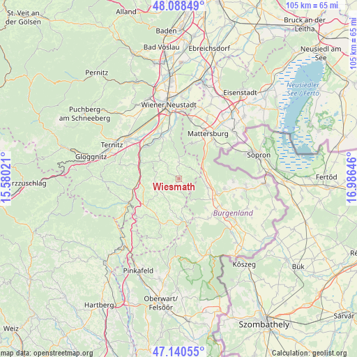
Wiesmath GPS coordinates[2]
47° 37' 0.012" North, 16° 16' 59.988" East
| Map corner | latitude | longitude |
|---|---|---|
| Upper-left | 48.08849°, | 15.58021° |
| Center: | 47.61667°, | 16.28333° |
| Lower-right: | 47.14055°, | 16.98646° |
| Map W x H: | 105.4×105.4 km | = 65.5×65.5mi |
| max Lat: | 48.98333° ⇑48.9% North |
| Wiesmath: | 47.61667° |
| min Lat: | ⇓51.1% South 46.48841° |
| min Long | Wiesmath | max Long |
| 9.57802° | 16.28333° | 17.1° |
| W 88.2%⇐ | ⇒11.8% E |
Elevation
Elevation of Wiesmath is 670 m = 2198 ft, and this is 164.5 m = 540 ft above average elevation for this country.
| Max E: |
2140 m = 7021 ft | 23.4% |
| Wiesmath | 670 m 2198 ft | |
| Avg. | 505.5 m = 1658 ft | |
Min E: |
118 m = 387 ft | 76.6% |
See also: Austria elevation on elevation.city.
Geographical zone
Wiesmath is located in North temperate zone (between Tropic of Cancer and the Arctic Circle). Distance of this North polar circle is 2106.7 km =1309 mi to North.| Distance of | km | miles | from Wiesmath |
|---|---|---|---|
| North Pole | 4712.6 | 2928.3 | to North |
| Arctic Circle | 2106.7 | 1309 | to North |
| Tropic Cancer | 2688.6 | 1670.6 | to South |
| Equator | 5294.5 | 3289.8 | to South |


Nearby cities:
15 places around Wiesmath: (largest is in red/bold)
• Bromberg
7.7 km =4.8 mi,  314°
314°
• Edlitz
10.9 km =6.8 mi,  259°
259°
• Forchtenstein
11.5 km =7.1 mi,  23°
23°
• Hochwolkersdorf
5 km =3.1 mi,  357°
357°
• Hollenthon
3.5 km =2.2 mi,  208°
208°
• Kobersdorf
8.5 km =5.3 mi,  105°
105°
• Lichtenegg
6.5 km =4 mi,  253°
253°
• Oberpetersdorf
7 km =4.3 mi,  91°
91°
• Schlatten
4.5 km =2.8 mi,  326°
326°
• Schwarzenbach
5.5 km =3.4 mi,  67°
67°
• Sieggraben
8.2 km =5.1 mi,  62°
62°
• Thernberg
8.4 km =5.2 mi,  296°
296°
• Tiefenbach
10.4 km =6.5 mi, 210°
• Tschurndorf
9.2 km =5.7 mi,  96°
96°
• Weppersdorf
11.5 km =7.1 mi, 110°
Sources, notices
• [Note1] Compared only with cities in Austria existing in our database
• [Src1] Map data: © OpenStreetMap contributors (CC-BY-SA)
• [Src2] Other city data from geonames.org with taken over terms of usage.
• [Src3] Geographical zone / Annual Mean Temperature by Robert A. Rohde @ Wikipedia
