Wyndham geodata
Wyndham (Western Australia) is a populated place; located in Australia in Australia/Perth (GMT+8) time zone. With population of 941 people, there are 3913 cities with bigger population in this country. Compared to other cities in Australia, 97.9% of cities are located further ↓South; 88.6% of cities are located further →East and 80.4% of cities have higher elevation than Wyndham. Note1


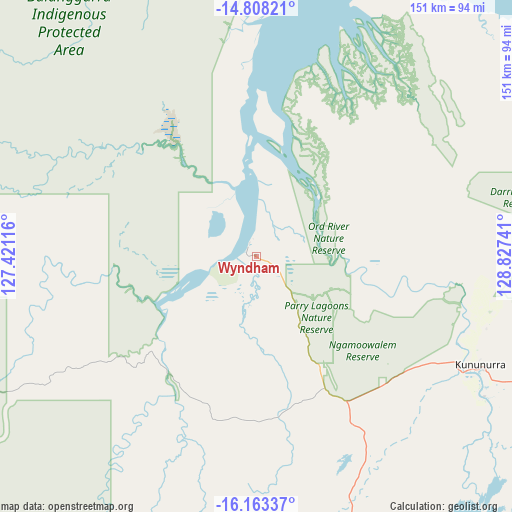
Wyndham GPS coordinates[2]
15° 29' 12.84" South, 128° 7' 27.408" East
| Map corner | latitude | longitude |
|---|---|---|
| Upper-left | -14.80821°, | 127.42116° |
| Center: | -15.4869°, | 128.12428° |
| Lower-right: | -16.16337°, | 128.82741° |
| Map W x H: | 150.7×150.7 km | = 93.6×93.6mi |
| max Lat: | -10.58257° ⇑2.1% North |
| Wyndham: | -15.4869° |
| min Lat: | ⇓97.9% South -43.31423° |
| min Long | Wyndham | max Long |
| 113.53327° | 128.12428° | 153.61246° |
| W 11.4%⇐ | ⇒88.6% E |
Elevation
Elevation of Wyndham is 15 m = 49 ft, and this is 107 m = 351 ft below average elevation for this country.
| Max E: |
1715 m = 5627 ft | 80.4% |
| Avg. | 122 m = 400 ft | |
| Wyndham | 15 m = 49 ft | |
Min E: |
-2 m = -7 ft | 19.6% |
See also: Australia elevation on elevation.city.
Geographical zone
Wyndham is located in South Torrid zone (between Equator and Tropic of Capricorn). Distance of this Southern Tropic circle is 883.9 km =549.2 mi to South.| Distance of | km | miles | from Wyndham |
|---|---|---|---|
| Equator | 1722 | 1070 | to North |
| Tropic Capricorn | 883.9 | 549.2 | to South |
| Antarctic Circle | 5679.2 | 3528.9 | to South |
| South Pole | 8285.1 | 5148.1 | to South |


Nearby cities:
10 places around Wyndham: (largest is in red/bold)
• Batchelor
414.1 km =257.3 mi,  49°
49°
• Darwin River
426.7 km =265.1 mi, 45°
• Douglas-Daly
394.6 km =245.2 mi,  61°
61°
• Fitzroy Crossing
406.1 km =252.3 mi,  222°
222°
• Halls Creek
308.3 km =191.6 mi,  189°
189°
• King Leopold Ranges
334.9 km =208.1 mi,  237°
237°
• Kununurra
73.7 km =45.8 mi,  116°
116°
• Lajamanu
414.6 km =257.6 mi,  139°
139°
• Lake Argyle
95.8 km =59.5 mi, 136°
• Wadeye
204.5 km =127.1 mi, 47°
Sources, notices
• [Note1] Compared only with cities in Australia existing in our database
• [Src1] Map data: © OpenStreetMap contributors (CC-BY-SA)
• [Src2] Other city data from geonames.org with taken over terms of usage.
• [Src3] Geographical zone / Annual Mean Temperature by Robert A. Rohde @ Wikipedia
