Kununurra geodata
Kununurra (Western Australia) is a populated place; located in Australia in Australia/Perth (GMT+8) time zone. With population of 6,836 people, there are 1005 cities with bigger population in this country. Compared to other cities in Australia, 97.9% of cities are located further ↓South; 88.5% of cities are located further →East and 54% of cities have lower elevation than Kununurra. Note1


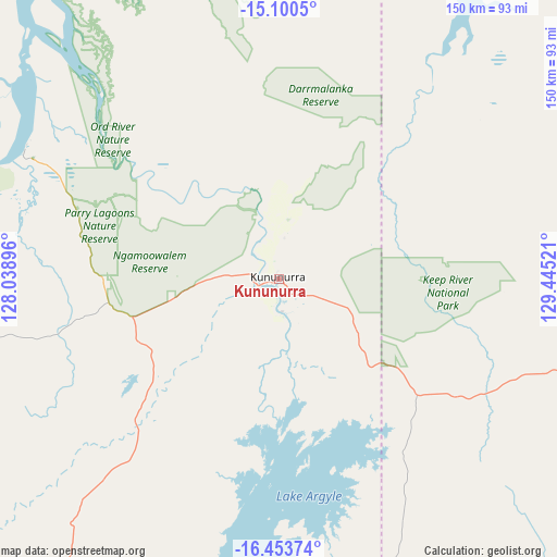
Kununurra GPS coordinates[2]
15° 46' 41.7" South, 128° 44' 31.488" East
| Map corner | latitude | longitude |
|---|---|---|
| Upper-left | -15.1005°, | 128.03896° |
| Center: | -15.77825°, | 128.74208° |
| Lower-right: | -16.45374°, | 129.44521° |
| Map W x H: | 150.5×150.5 km | = 93.5×93.5mi |
| max Lat: | -10.58257° ⇑2.1% North |
| Kununurra: | -15.77825° |
| min Lat: | ⇓97.9% South -43.31423° |
| min Long | Kununurra | max Long |
| 113.53327° | 128.74208° | 153.61246° |
| W 11.5%⇐ | ⇒88.5% E |
Elevation
Elevation of Kununurra is 51 m = 167 ft, and this is 71 m = 233 ft below average elevation for this country.
| Max E: |
1715 m = 5627 ft | 46% |
| Avg. | 122 m = 400 ft | |
| Kununurra | 51 m = 167 ft | |
Min E: |
-2 m = -7 ft | 54% |
See also: Australia elevation on elevation.city.
Geographical zone
Kununurra is located in South Torrid zone (between Equator and Tropic of Capricorn). Distance of this Southern Tropic circle is 851.5 km =529.1 mi to South.| Distance of | km | miles | from Kununurra |
|---|---|---|---|
| Equator | 1754.4 | 1090.1 | to North |
| Tropic Capricorn | 851.5 | 529.1 | to South |
| Antarctic Circle | 5646.8 | 3508.8 | to South |
| South Pole | 8252.7 | 5128 | to South |


Nearby cities:
15 places around Kununurra: (largest is in red/bold)
• Batchelor
390.8 km =242.8 mi,  39°
39°
• Cossack
396.7 km =246.5 mi,  68°
68°
• Darwin River
407.2 km =253 mi, 36°
• Douglas-Daly
356.5 km =221.5 mi,  51°
51°
• Halls Creek
295.1 km =183.4 mi,  202°
202°
• Katherine
405.2 km =251.8 mi, 68°
• Katherine East
407.4 km =253.1 mi, 69°
• Katherine South
404.6 km =251.4 mi, 68°
• King Leopold Ranges
378 km =234.9 mi,  246°
246°
• Lajamanu
348.6 km =216.6 mi,  144°
144°
• Lake Argyle
37.5 km =23.3 mi,  180°
180°
• Lansdowne
419 km =260.4 mi, 69°
• Tindal
414.2 km =257.4 mi, 70°
• Wadeye
190.6 km =118.4 mi,  26°
26°
• Wyndham
73.7 km =45.8 mi,  296°
296°
Sources, notices
• [Note1] Compared only with cities in Australia existing in our database
• [Src1] Map data: © OpenStreetMap contributors (CC-BY-SA)
• [Src2] Other city data from geonames.org with taken over terms of usage.
• [Src3] Geographical zone / Annual Mean Temperature by Robert A. Rohde @ Wikipedia
