Roxby Downs geodata
Roxby Downs (South Australia) is a populated place; located in Australia in Australia/Adelaide (GMT+10.5) time zone. With population of 4,616 people, there are 1594 cities with bigger population in this country. Compared to other cities in Australia, 71.5% of cities are located further ↓South; 85.9% of cities are located further →East and 70.7% of cities have lower elevation than Roxby Downs. Note1


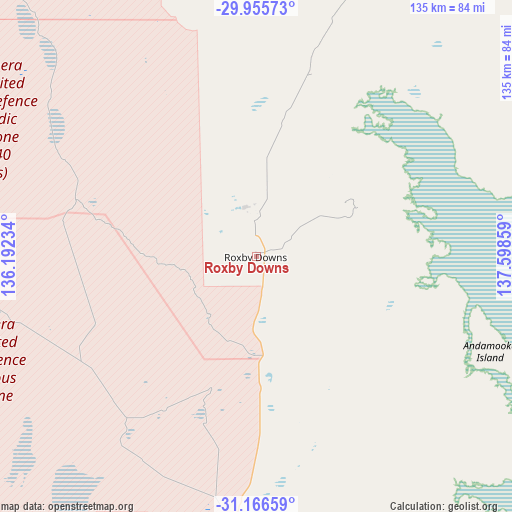
Roxby Downs GPS coordinates[2]
30° 33' 46.98" South, 136° 53' 43.656" East
| Map corner | latitude | longitude |
|---|---|---|
| Upper-left | -29.95573°, | 136.19234° |
| Center: | -30.56305°, | 136.89546° |
| Lower-right: | -31.16659°, | 137.59859° |
| Map W x H: | 134.6×134.6 km | = 83.6×83.6mi |
| max Lat: | -10.58257° ⇑28.5% North |
| Roxby Downs: | -30.56305° |
| min Lat: | ⇓71.5% South -43.31423° |
| min Long | Roxby Downs | max Long |
| 113.53327° | 136.89546° | 153.61246° |
| W 14.1%⇐ | ⇒85.9% E |
Elevation
Elevation of Roxby Downs is 107 m = 351 ft, and this is 15 m = 49 ft below average elevation for this country.
| Max E: |
1715 m = 5627 ft | 29.3% |
| Avg. | 122 m = 400 ft | |
| Roxby Downs | 107 m = 351 ft | |
Min E: |
-2 m = -7 ft | 70.7% |
See also: Australia elevation on elevation.city.
Geographical zone
Roxby Downs is located in South temperate zone (between Tropic of Capricorn and the Antarctic Circle). Distance of this Southern Tropic circle is 792.4 km =492.4 mi to North.| Distance of | km | miles | from Roxby Downs |
|---|---|---|---|
| Equator | 3398.3 | 2111.6 | to North |
| Tropic Capricorn | 792.4 | 492.4 | to North |
| Antarctic Circle | 4002.9 | 2487.3 | to South |
| South Pole | 6608.8 | 4106.5 | to South |


Nearby cities:
15 places around Roxby Downs: (largest is in red/bold)
• Coober Pedy
268.9 km =167.1 mi,  309°
309°
• Kimba
290.2 km =180.3 mi,  188°
188°
• Orroroo
291.1 km =180.9 mi,  146°
146°
• Port Augusta
230.4 km =143.2 mi,  158°
158°
• Port Augusta West
228.9 km =142.2 mi, 159°
• Port Pirie West
308.8 km =191.9 mi, 160°
• Quorn
226.2 km =140.6 mi, 151°
• Stirling North
231.1 km =143.6 mi, 157°
• Whyalla
281.8 km =175.1 mi,  167°
167°
• Whyalla Jenkins
279.6 km =173.7 mi, 167°
• Whyalla Norrie
280.9 km =174.5 mi, 167°
• Whyalla Playford
281.2 km =174.7 mi, 167°
• Whyalla Stuart
280.1 km =174 mi, 167°
• Wilmington
258.5 km =160.6 mi, 153°
• Wudinna
307.8 km =191.3 mi,  206°
206°
Sources, notices
• [Note1] Compared only with cities in Australia existing in our database
• [Src1] Map data: © OpenStreetMap contributors (CC-BY-SA)
• [Src2] Other city data from geonames.org with taken over terms of usage.
• [Src3] Geographical zone / Annual Mean Temperature by Robert A. Rohde @ Wikipedia
