Wudinna geodata
Wudinna (South Australia) is a populated place; located in Australia in Australia/Adelaide (GMT+10.5) time zone. With population of 738 people, there are 4264 cities with bigger population in this country. Compared to other cities in Australia, 57.1% of cities are located further ↓South; 86.2% of cities are located further →East and 67.6% of cities have lower elevation than Wudinna. Note1


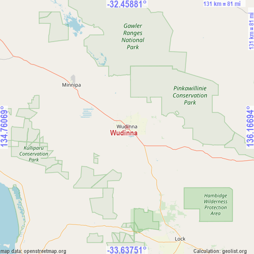
Wudinna GPS coordinates[2]
33° 3' 0.468" South, 135° 27' 49.716" East
| Map corner | latitude | longitude |
|---|---|---|
| Upper-left | -32.45881°, | 134.76069° |
| Center: | -33.05013°, | 135.46381° |
| Lower-right: | -33.63751°, | 136.16694° |
| Map W x H: | 131.1×131.1 km | = 81.5×81.5mi |
| max Lat: | -10.58257° ⇑42.9% North |
| Wudinna: | -33.05013° |
| min Lat: | ⇓57.1% South -43.31423° |
| min Long | Wudinna | max Long |
| 113.53327° | 135.46381° | 153.61246° |
| W 13.8%⇐ | ⇒86.2% E |
Elevation
Elevation of Wudinna is 91 m = 299 ft, and this is 31 m = 102 ft below average elevation for this country.
| Max E: |
1715 m = 5627 ft | 32.4% |
| Avg. | 122 m = 400 ft | |
| Wudinna | 91 m = 299 ft | |
Min E: |
-2 m = -7 ft | 67.6% |
See also: Australia elevation on elevation.city.
Geographical zone
Wudinna is located in South temperate zone (between Tropic of Capricorn and the Antarctic Circle). Distance of this Southern Tropic circle is 1068.9 km =664.2 mi to North.| Distance of | km | miles | from Wudinna |
|---|---|---|---|
| Equator | 3674.8 | 2283.4 | to North |
| Tropic Capricorn | 1068.9 | 664.2 | to North |
| Antarctic Circle | 3726.3 | 2315.4 | to South |
| South Pole | 6332.2 | 3934.6 | to South |


Nearby cities:
15 places around Wudinna: (largest is in red/bold)
• Arno Bay
139.3 km =86.6 mi,  132°
132°
• Cleve
120.3 km =74.8 mi, 126°
• Coffin Bay
170.7 km =106.1 mi,  184°
184°
• Cowell
152.5 km =94.8 mi,  117°
117°
• Cummins
137.1 km =85.2 mi,  169°
169°
• Kimba
89.5 km =55.6 mi,  96°
96°
• Port Lincoln
190.2 km =118.2 mi, 168°
• Smoky Bay
161.4 km =100.3 mi,  297°
297°
• Streaky Bay
120.5 km =74.9 mi,  283°
283°
• Tumby Bay
158.9 km =98.7 mi,  158°
158°
• Whyalla
195.8 km =121.7 mi,  89°
89°
• Whyalla Jenkins
191 km =118.7 mi, 89°
• Whyalla Norrie
193.5 km =120.2 mi, 89°
• Whyalla Playford
195.6 km =121.5 mi, 89°
• Whyalla Stuart
192.1 km =119.4 mi, 89°
Sources, notices
• [Note1] Compared only with cities in Australia existing in our database
• [Src1] Map data: © OpenStreetMap contributors (CC-BY-SA)
• [Src2] Other city data from geonames.org with taken over terms of usage.
• [Src3] Geographical zone / Annual Mean Temperature by Robert A. Rohde @ Wikipedia
