Minlaton geodata
Minlaton (South Australia) is a populated place; located in Australia in Australia/Adelaide (GMT+10.5) time zone. With population of 1,060 people, there are 3742 cities with bigger population in this country. Compared to other cities in Australia, 65.4% of cities are located further ↑North; 85.7% of cities are located further →East and 63.4% of cities have lower elevation than Minlaton. Note1


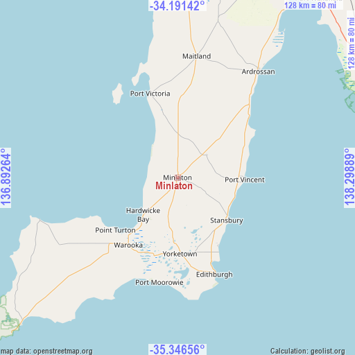
Minlaton GPS coordinates[2]
34° 46' 15.636" South, 137° 35' 44.736" East
| Map corner | latitude | longitude |
|---|---|---|
| Upper-left | -34.19142°, | 136.89264° |
| Center: | -34.77101°, | 137.59576° |
| Lower-right: | -35.34656°, | 138.29889° |
| Map W x H: | 128.4×128.4 km | = 79.8×79.8mi |
| max Lat: | -10.58257° ⇑65.4% North |
| Minlaton: | -34.77101° |
| min Lat: | ⇓34.6% South -43.31423° |
| min Long | Minlaton | max Long |
| 113.53327° | 137.59576° | 153.61246° |
| W 14.3%⇐ | ⇒85.7% E |
Elevation
Elevation of Minlaton is 74 m = 243 ft, and this is 48 m = 157 ft below average elevation for this country.
| Max E: |
1715 m = 5627 ft | 36.6% |
| Avg. | 122 m = 400 ft | |
| Minlaton | 74 m = 243 ft | |
Min E: |
-2 m = -7 ft | 63.4% |
See also: Australia elevation on elevation.city.
Geographical zone
Minlaton is located in South temperate zone (between Tropic of Capricorn and the Antarctic Circle). Distance of this Southern Tropic circle is 1260.3 km =783.1 mi to North.| Distance of | km | miles | from Minlaton |
|---|---|---|---|
| Equator | 3866.2 | 2402.3 | to North |
| Tropic Capricorn | 1260.3 | 783.1 | to North |
| Antarctic Circle | 3535 | 2196.5 | to South |
| South Pole | 6140.9 | 3815.8 | to South |


Nearby cities:
15 places around Minlaton: (largest is in red/bold)
• Ardrossan
48.8 km =30.3 mi,  37°
37°
• Exeter
81.9 km =50.9 mi,  95°
95°
• Honiton
38.8 km =24.1 mi,  172°
172°
• Largs Bay
81.5 km =50.6 mi,  94°
94°
• Maitland
44.7 km =27.8 mi,  9°
9°
• Moonta
78.1 km =48.5 mi,  359°
359°
• Moonta Bay
80.2 km =49.8 mi, 358°
• North Haven
81.8 km =50.8 mi, 91°
• North Moonta
79.8 km =49.6 mi, 359°
• Port Hughes
76.6 km =47.6 mi, 356°
• Semaphore
81.3 km =50.5 mi, 95°
• Semaphore Park
81.1 km =50.4 mi, 96°
• Semaphore South
81.2 km =50.5 mi, 96°
• Stansbury
24.2 km =15 mi,  130°
130°
• Yorketown
27.5 km =17.1 mi,  178°
178°
Sources, notices
• [Note1] Compared only with cities in Australia existing in our database
• [Src1] Map data: © OpenStreetMap contributors (CC-BY-SA)
• [Src2] Other city data from geonames.org with taken over terms of usage.
• [Src3] Geographical zone / Annual Mean Temperature by Robert A. Rohde @ Wikipedia
