Bindoon geodata
Bindoon (Western Australia) is a populated place; located in Australia in Australia/Perth (GMT+8) time zone. With population of 1,156 people, there are 3633 cities with bigger population in this country. Compared to other cities in Australia, 69.9% of cities are located further ↓South; 91.5% of cities are located further →East and 76% of cities have lower elevation than Bindoon. Note1


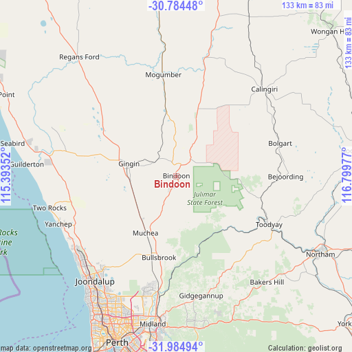
Bindoon GPS coordinates[2]
31° 23' 11.868" South, 116° 5' 47.904" East
| Map corner | latitude | longitude |
|---|---|---|
| Upper-left | -30.78448°, | 115.39352° |
| Center: | -31.38663°, | 116.09664° |
| Lower-right: | -31.98494°, | 116.79977° |
| Map W x H: | 133.5×133.5 km | = 83×83mi |
| max Lat: | -10.58257° ⇑30.1% North |
| Bindoon: | -31.38663° |
| min Lat: | ⇓69.9% South -43.31423° |
| min Long | Bindoon | max Long |
| 113.53327° | 116.09664° | 153.61246° |
| W 8.5%⇐ | ⇒91.5% E |
Elevation
Elevation of Bindoon is 138 m = 453 ft, and this is 16 m = 52 ft above average elevation for this country.
| Max E: |
1715 m = 5627 ft | 24% |
| Bindoon | 138 m 453 ft | |
| Avg. | 122 m = 400 ft | |
Min E: |
-2 m = -7 ft | 76% |
See also: Australia elevation on elevation.city.
Geographical zone
Bindoon is located in South temperate zone (between Tropic of Capricorn and the Antarctic Circle). Distance of this Southern Tropic circle is 883.9 km =549.2 mi to North.| Distance of | km | miles | from Bindoon |
|---|---|---|---|
| Equator | 3489.9 | 2168.5 | to North |
| Tropic Capricorn | 883.9 | 549.2 | to North |
| Antarctic Circle | 3911.3 | 2430.4 | to South |
| South Pole | 6517.2 | 4049.6 | to South |


Nearby cities:
15 places around Bindoon: (largest is in red/bold)
• Brigadoon
43 km =26.7 mi,  183°
183°
• Bullsbrook
32.7 km =20.3 mi,  196°
196°
• Chittering
9.1 km =5.7 mi,  189°
189°
• Coondle
33.1 km =20.6 mi,  108°
108°
• Gidgegannup
41.8 km =26 mi,  168°
168°
• Gingin
18.8 km =11.7 mi,  283°
283°
• Lower Chittering
22 km =13.7 mi, 175°
• Mariginiup
43.3 km =26.9 mi,  213°
213°
• Morangup
36.4 km =22.6 mi,  149°
149°
• Muchea
24.8 km =15.4 mi, 208°
• Pearce
32 km =19.9 mi, 193°
• The Vines
41.9 km =26 mi, 192°
• Toodyay
39.6 km =24.6 mi,  117°
117°
• Upper Swan
43.1 km =26.8 mi, 188°
• West Toodyay
34.5 km =21.4 mi, 118°
Sources, notices
• [Note1] Compared only with cities in Australia existing in our database
• [Src1] Map data: © OpenStreetMap contributors (CC-BY-SA)
• [Src2] Other city data from geonames.org with taken over terms of usage.
• [Src3] Geographical zone / Annual Mean Temperature by Robert A. Rohde @ Wikipedia
