Angaston geodata
Angaston (South Australia) is a populated place; located in Australia in Australia/Adelaide (GMT+10.5) time zone. With population of 2,058 people, there are 2862 cities with bigger population in this country. Compared to other cities in Australia, 63.3% of cities are located further ↑North; 76.6% of cities are located further →East and 89.2% of cities have lower elevation than Angaston. Note1


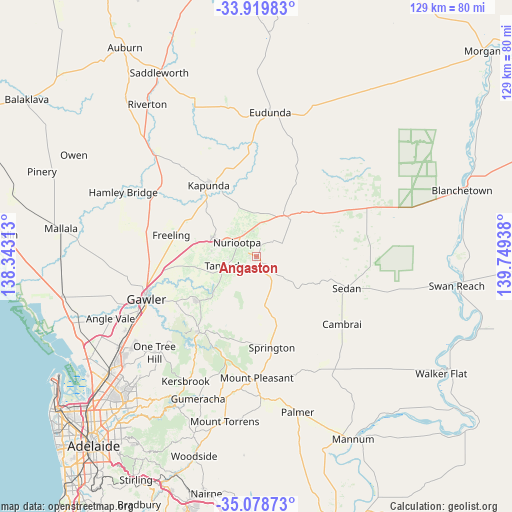
Angaston GPS coordinates[2]
34° 30' 4.644" South, 139° 2' 46.5" East
| Map corner | latitude | longitude |
|---|---|---|
| Upper-left | -33.91983°, | 138.34313° |
| Center: | -34.50129°, | 139.04625° |
| Lower-right: | -35.07873°, | 139.74938° |
| Map W x H: | 128.9×128.9 km | = 80.1×80.1mi |
| max Lat: | -10.58257° ⇑63.3% North |
| Angaston: | -34.50129° |
| min Lat: | ⇓36.7% South -43.31423° |
| min Long | Angaston | max Long |
| 113.53327° | 139.04625° | 153.61246° |
| W 23.4%⇐ | ⇒76.6% E |
Elevation
Elevation of Angaston is 353 m = 1158 ft, and this is 231 m = 758 ft above average elevation for this country.
| Max E: |
1715 m = 5627 ft | 10.8% |
| Angaston | 353 m 1158 ft | |
| Avg. | 122 m = 400 ft | |
Min E: |
-2 m = -7 ft | 89.2% |
See also: Australia elevation on elevation.city.
Geographical zone
Angaston is located in South temperate zone (between Tropic of Capricorn and the Antarctic Circle). Distance of this Southern Tropic circle is 1230.3 km =764.5 mi to North.| Distance of | km | miles | from Angaston |
|---|---|---|---|
| Equator | 3836.2 | 2383.7 | to North |
| Tropic Capricorn | 1230.3 | 764.5 | to North |
| Antarctic Circle | 3565 | 2215.2 | to South |
| South Pole | 6170.9 | 3834.4 | to South |


Nearby cities:
15 places around Angaston: (largest is in red/bold)
• Cockatoo Valley
23.6 km =14.7 mi,  234°
234°
• Freeling
22.4 km =13.9 mi,  283°
283°
• Gawler
29.5 km =18.3 mi,  247°
247°
• Gawler East
28.1 km =17.5 mi, 247°
• Greenock
12 km =7.5 mi,  294°
294°
• Hewett
28.2 km =17.5 mi, 252°
• Kapunda
21.6 km =13.4 mi,  326°
326°
• Lyndoch
18 km =11.2 mi, 231°
• Nuriootpa
5.8 km =3.6 mi,  309°
309°
• Roseworthy
27.4 km =17 mi,  262°
262°
• Springton
23.3 km =14.5 mi,  170°
170°
• Tanunda
8.3 km =5.2 mi, 252°
• Truro
12.7 km =7.9 mi,  35°
35°
• Willaston
29.5 km =18.3 mi, 251°
• Williamstown
23.7 km =14.7 mi,  216°
216°
Sources, notices
• [Note1] Compared only with cities in Australia existing in our database
• [Src1] Map data: © OpenStreetMap contributors (CC-BY-SA)
• [Src2] Other city data from geonames.org with taken over terms of usage.
• [Src3] Geographical zone / Annual Mean Temperature by Robert A. Rohde @ Wikipedia
