Hillston geodata
Hillston (New South Wales) is a populated place; located in Australia in Australia/Sydney (GMT+11) time zone. With population of 1,448 people, there are 3322 cities with bigger population in this country. Compared to other cities in Australia, 53.7% of cities are located further ↓South; 59.5% of cities are located further →East and 73.9% of cities have lower elevation than Hillston. Note1


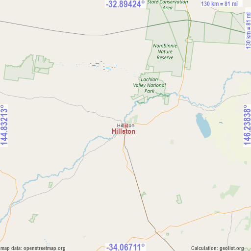
Hillston GPS coordinates[2]
33° 28' 57.576" South, 145° 32' 6.9" East
| Map corner | latitude | longitude |
|---|---|---|
| Upper-left | -32.89424°, | 144.83213° |
| Center: | -33.48266°, | 145.53525° |
| Lower-right: | -34.06711°, | 146.23838° |
| Map W x H: | 130.4×130.4 km | = 81×81mi |
| max Lat: | -10.58257° ⇑46.3% North |
| Hillston: | -33.48266° |
| min Lat: | ⇓53.7% South -43.31423° |
| min Long | Hillston | max Long |
| 113.53327° | 145.53525° | 153.61246° |
| W 40.5%⇐ | ⇒59.5% E |
Elevation
Elevation of Hillston is 122 m = 400 ft, and this is 0 m = 0 ft above average elevation for this country.
| Max E: |
1715 m = 5627 ft | 26.1% |
| Hillston | 122 m 400 ft | |
| Avg. | 122 m = 400 ft | |
Min E: |
-2 m = -7 ft | 73.9% |
See also: Australia elevation on elevation.city.
Geographical zone
Hillston is located in South temperate zone (between Tropic of Capricorn and the Antarctic Circle). Distance of this Southern Tropic circle is 1117 km =694.1 mi to North.| Distance of | km | miles | from Hillston |
|---|---|---|---|
| Equator | 3722.9 | 2313.3 | to North |
| Tropic Capricorn | 1117 | 694.1 | to North |
| Antarctic Circle | 3678.3 | 2285.6 | to South |
| South Pole | 6284.1 | 3904.8 | to South |


Nearby cities:
15 places around Hillston: (largest is in red/bold)
• Barellan
130.8 km =81.3 mi,  132°
132°
• Bilbul
104 km =64.6 mi,  147°
147°
• Coleambally
150.3 km =93.4 mi,  167°
167°
• Darlington Point
128.2 km =79.7 mi,  160°
160°
• Griffith
101.5 km =63.1 mi, 152°
• Hanwood
105.3 km =65.4 mi, 153°
• Hay
130.7 km =81.2 mi,  209°
209°
• Lake Cargelligo
80.4 km =50 mi,  75°
75°
• Lake Wyangan
94.6 km =58.8 mi, 151°
• Leeton
143.3 km =89 mi, 145°
• Tharbogang
96.8 km =60.1 mi, 154°
• Ungarie
134.6 km =83.6 mi,  97°
97°
• Yanco
147.9 km =91.9 mi, 147°
• Yenda
104.8 km =65.1 mi,  143°
143°
• Yoogali
104 km =64.6 mi, 150°
Sources, notices
• [Note1] Compared only with cities in Australia existing in our database
• [Src1] Map data: © OpenStreetMap contributors (CC-BY-SA)
• [Src2] Other city data from geonames.org with taken over terms of usage.
• [Src3] Geographical zone / Annual Mean Temperature by Robert A. Rohde @ Wikipedia
