Ardlethan geodata
Ardlethan (New South Wales) is a populated place; located in Australia in Australia/Sydney (GMT+11) time zone. With population of 508 people, there are 4859 cities with bigger population in this country. Compared to other cities in Australia, 62.1% of cities are located further ↑North; 53.6% of cities are located further →East and 81.6% of cities have lower elevation than Ardlethan. Note1


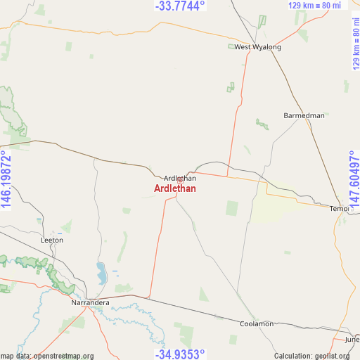
Ardlethan GPS coordinates[2]
34° 21' 24.696" South, 146° 54' 6.624" East
| Map corner | latitude | longitude |
|---|---|---|
| Upper-left | -33.7744°, | 146.19872° |
| Center: | -34.35686°, | 146.90184° |
| Lower-right: | -34.9353°, | 147.60497° |
| Map W x H: | 129.1×129.1 km | = 80.2×80.2mi |
| max Lat: | -10.58257° ⇑62.1% North |
| Ardlethan: | -34.35686° |
| min Lat: | ⇓37.9% South -43.31423° |
| min Long | Ardlethan | max Long |
| 113.53327° | 146.90184° | 153.61246° |
| W 46.4%⇐ | ⇒53.6% E |
Elevation
Elevation of Ardlethan is 200 m = 656 ft, and this is 78 m = 256 ft above average elevation for this country.
| Max E: |
1715 m = 5627 ft | 18.4% |
| Ardlethan | 200 m 656 ft | |
| Avg. | 122 m = 400 ft | |
Min E: |
-2 m = -7 ft | 81.6% |
See also: Australia elevation on elevation.city.
Geographical zone
Ardlethan is located in South temperate zone (between Tropic of Capricorn and the Antarctic Circle). Distance of this Southern Tropic circle is 1214.2 km =754.5 mi to North.| Distance of | km | miles | from Ardlethan |
|---|---|---|---|
| Equator | 3820.1 | 2373.7 | to North |
| Tropic Capricorn | 1214.2 | 754.5 | to North |
| Antarctic Circle | 3581 | 2225.1 | to South |
| South Pole | 6186.9 | 3844.4 | to South |


Nearby cities:
15 places around Ardlethan: (largest is in red/bold)
• Barellan
31.3 km =19.4 mi,  284°
284°
• Bilbul
70.6 km =43.9 mi, 277°
• Coolamon
57.7 km =35.9 mi,  152°
152°
• Ganmain
50.1 km =31.1 mi,  165°
165°
• Griffith
78.5 km =48.8 mi, 275°
• Hanwood
79 km =49.1 mi,  272°
272°
• Leeton
50.4 km =31.3 mi,  244°
244°
• Narrandera
54 km =33.6 mi,  216°
216°
• Temora
59 km =36.7 mi,  99°
99°
• Ungarie
79.8 km =49.6 mi,  4°
4°
• West Wyalong
55.6 km =34.5 mi,  30°
30°
• Wyalong
57.3 km =35.6 mi, 33°
• Yanco
52.5 km =32.6 mi, 239°
• Yenda
65.4 km =40.6 mi, 280°
• Yoogali
75.3 km =46.8 mi, 274°
Sources, notices
• [Note1] Compared only with cities in Australia existing in our database
• [Src1] Map data: © OpenStreetMap contributors (CC-BY-SA)
• [Src2] Other city data from geonames.org with taken over terms of usage.
• [Src3] Geographical zone / Annual Mean Temperature by Robert A. Rohde @ Wikipedia
