Ungarie geodata
Ungarie (New South Wales) is a populated place; located in Australia in Australia/Sydney (GMT+11) time zone. With population of 542 people, there are 4740 cities with bigger population in this country. Compared to other cities in Australia, 52.2% of cities are located further ↓South; 53.3% of cities are located further →East and 83.7% of cities have lower elevation than Ungarie. Note1


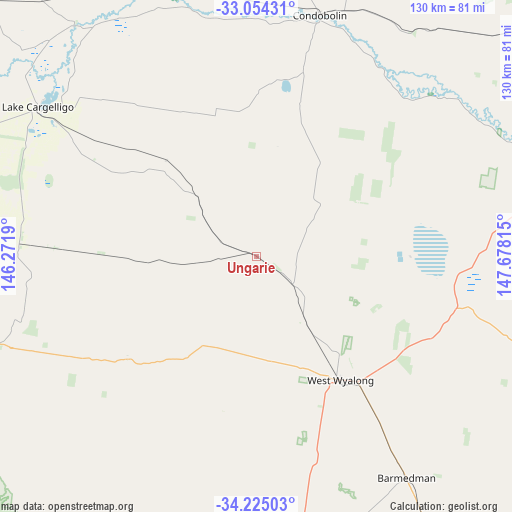
Ungarie GPS coordinates[2]
33° 38' 29.976" South, 146° 58' 30.072" East
| Map corner | latitude | longitude |
|---|---|---|
| Upper-left | -33.05431°, | 146.2719° |
| Center: | -33.64166°, | 146.97502° |
| Lower-right: | -34.22503°, | 147.67815° |
| Map W x H: | 130.2×130.2 km | = 80.9×80.9mi |
| max Lat: | -10.58257° ⇑47.8% North |
| Ungarie: | -33.64166° |
| min Lat: | ⇓52.2% South -43.31423° |
| min Long | Ungarie | max Long |
| 113.53327° | 146.97502° | 153.61246° |
| W 46.7%⇐ | ⇒53.3% E |
Elevation
Elevation of Ungarie is 226 m = 741 ft, and this is 104 m = 341 ft above average elevation for this country.
| Max E: |
1715 m = 5627 ft | 16.3% |
| Ungarie | 226 m 741 ft | |
| Avg. | 122 m = 400 ft | |
Min E: |
-2 m = -7 ft | 83.7% |
See also: Australia elevation on elevation.city.
Geographical zone
Ungarie is located in South temperate zone (between Tropic of Capricorn and the Antarctic Circle). Distance of this Southern Tropic circle is 1134.7 km =705.1 mi to North.| Distance of | km | miles | from Ungarie |
|---|---|---|---|
| Equator | 3740.6 | 2324.3 | to North |
| Tropic Capricorn | 1134.7 | 705.1 | to North |
| Antarctic Circle | 3660.6 | 2274.6 | to South |
| South Pole | 6266.5 | 3893.8 | to South |


Nearby cities:
15 places around Ungarie: (largest is in red/bold)
• Ardlethan
79.8 km =49.6 mi,  184°
184°
• Barellan
80.6 km =50.1 mi,  207°
207°
• Bilbul
104.1 km =64.7 mi,  227°
227°
• Condobolin
63.6 km =39.5 mi,  14°
14°
• Forbes
99.9 km =62.1 mi,  73°
73°
• Grenfell
113.5 km =70.5 mi,  104°
104°
• Griffith
111.5 km =69.3 mi, 229°
• Lake Cargelligo
67.6 km =42 mi,  304°
304°
• Lake Wyangan
109.8 km =68.2 mi, 233°
• Temora
103.5 km =64.3 mi,  150°
150°
• Trundle
105 km =65.2 mi,  40°
40°
• West Wyalong
37.9 km =23.5 mi, 145°
• Wyalong
40.1 km =24.9 mi,  141°
141°
• Yenda
97.9 km =60.8 mi, 226°
• Yoogali
110 km =68.4 mi, 228°
Sources, notices
• [Note1] Compared only with cities in Australia existing in our database
• [Src1] Map data: © OpenStreetMap contributors (CC-BY-SA)
• [Src2] Other city data from geonames.org with taken over terms of usage.
• [Src3] Geographical zone / Annual Mean Temperature by Robert A. Rohde @ Wikipedia
