Bonnie Doon geodata
Bonnie Doon (Victoria) is a populated place; located in Australia in Australia/Melbourne (GMT+11) time zone. With population of 541 people, there are 4743 cities with bigger population in this country. Compared to other cities in Australia, 81.5% of cities are located further ↑North; 57.7% of cities are located further →East and 86.7% of cities have lower elevation than Bonnie Doon. Note1


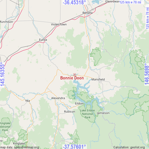
Bonnie Doon GPS coordinates[2]
37° 1' 0.012" South, 145° 52' 0.012" East
| Map corner | latitude | longitude |
|---|---|---|
| Upper-left | -36.45318°, | 145.16355° |
| Center: | -37.01667°, | 145.86667° |
| Lower-right: | -37.57601°, | 146.5698° |
| Map W x H: | 124.8×124.8 km | = 77.5×77.5mi |
| max Lat: | -10.58257° ⇑81.5% North |
| Bonnie Doon: | -37.01667° |
| min Lat: | ⇓18.5% South -43.31423° |
| min Long | Bonnie Doon | max Long |
| 113.53327° | 145.86667° | 153.61246° |
| W 42.3%⇐ | ⇒57.7% E |
Elevation
Elevation of Bonnie Doon is 281 m = 922 ft, and this is 159 m = 522 ft above average elevation for this country.
| Max E: |
1715 m = 5627 ft | 13.3% |
| Bonnie Doon | 281 m 922 ft | |
| Avg. | 122 m = 400 ft | |
Min E: |
-2 m = -7 ft | 86.7% |
See also: Australia elevation on elevation.city.
Geographical zone
Bonnie Doon is located in South temperate zone (between Tropic of Capricorn and the Antarctic Circle). Distance of this Southern Tropic circle is 1509.9 km =938.2 mi to North.| Distance of | km | miles | from Bonnie Doon |
|---|---|---|---|
| Equator | 4115.9 | 2557.5 | to North |
| Tropic Capricorn | 1509.9 | 938.2 | to North |
| Antarctic Circle | 3285.3 | 2041.4 | to South |
| South Pole | 5891.2 | 3660.6 | to South |


Nearby cities:
15 places around Bonnie Doon: (largest is in red/bold)
• Alexandra
23.8 km =14.8 mi,  215°
215°
• Avenel
57.7 km =35.9 mi,  282°
282°
• Benalla
52.8 km =32.8 mi,  11°
11°
• Eildon
24.3 km =15.1 mi,  170°
170°
• Euroa
39.2 km =24.4 mi,  317°
317°
• Flowerdale
58.9 km =36.6 mi,  233°
233°
• Glenrowan
69.3 km =43.1 mi,  27°
27°
• Mansfield
20.1 km =12.5 mi,  101°
101°
• Merrijig
35.3 km =21.9 mi,  105°
105°
• Mount Buller
52.6 km =32.7 mi, 105°
• Nagambie
68.4 km =42.5 mi,  292°
292°
• Seymour
64.6 km =40.1 mi,  269°
269°
• Tallarook
68.6 km =42.6 mi,  262°
262°
• Violet Town
44.4 km =27.6 mi,  342°
342°
• Yea
44.5 km =27.7 mi,  241°
241°
Sources, notices
• [Note1] Compared only with cities in Australia existing in our database
• [Src1] Map data: © OpenStreetMap contributors (CC-BY-SA)
• [Src2] Other city data from geonames.org with taken over terms of usage.
• [Src3] Geographical zone / Annual Mean Temperature by Robert A. Rohde @ Wikipedia
