Tumut geodata
Tumut (New South Wales) is a populated place; located in Australia in Australia/Sydney (GMT+11) time zone. With population of 6,167 people, there are 1162 cities with bigger population in this country. Compared to other cities in Australia, 75.5% of cities are located further ↑North; 51.3% of cities are located further ←West and 88.1% of cities have lower elevation than Tumut. Note1


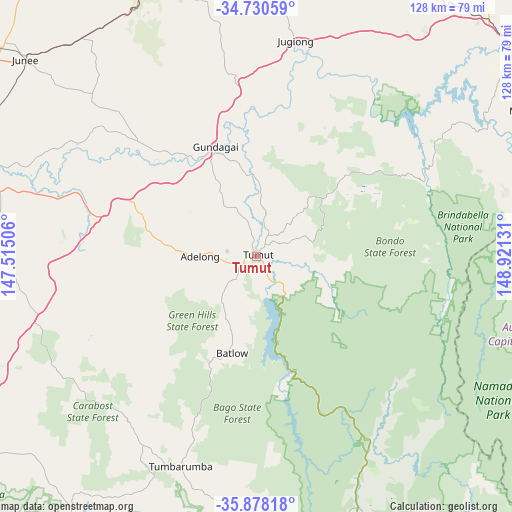
Tumut GPS coordinates[2]
35° 18' 23.112" South, 148° 13' 5.448" East
| Map corner | latitude | longitude |
|---|---|---|
| Upper-left | -34.73059°, | 147.51506° |
| Center: | -35.30642°, | 148.21818° |
| Lower-right: | -35.87818°, | 148.92131° |
| Map W x H: | 127.6×127.6 km | = 79.3×79.3mi |
| max Lat: | -10.58257° ⇑75.5% North |
| Tumut: | -35.30642° |
| min Lat: | ⇓24.5% South -43.31423° |
| min Long | Tumut | max Long |
| 113.53327° | 148.21818° | 153.61246° |
| W 51.3%⇐ | ⇒48.7% E |
Elevation
Elevation of Tumut is 316 m = 1037 ft, and this is 194 m = 636 ft above average elevation for this country.
| Max E: |
1715 m = 5627 ft | 11.9% |
| Tumut | 316 m 1037 ft | |
| Avg. | 122 m = 400 ft | |
Min E: |
-2 m = -7 ft | 88.1% |
See also: Australia elevation on elevation.city.
Geographical zone
Tumut is located in South temperate zone (between Tropic of Capricorn and the Antarctic Circle). Distance of this Southern Tropic circle is 1319.8 km =820.1 mi to North.| Distance of | km | miles | from Tumut |
|---|---|---|---|
| Equator | 3925.7 | 2439.3 | to North |
| Tropic Capricorn | 1319.8 | 820.1 | to North |
| Antarctic Circle | 3475.5 | 2159.6 | to South |
| South Pole | 6081.4 | 3778.8 | to South |


Nearby cities:
15 places around Tumut: (largest is in red/bold)
• Adelong
13.5 km =8.4 mi,  270°
270°
• Batlow
24.6 km =15.3 mi,  195°
195°
• Coombs
74.5 km =46.3 mi,  90°
90°
• Duffy
73.9 km =45.9 mi, 92°
• Dunlop
73.9 km =45.9 mi,  80°
80°
• Forest Hill
70.5 km =43.8 mi,  284°
284°
• Gundagai
28.9 km =18 mi,  338°
338°
• Higgins
73.9 km =45.9 mi, 83°
• Holt
72.6 km =45.1 mi, 82°
• Latham
74.5 km =46.3 mi, 82°
• Macgregor
72.8 km =45.2 mi, 81°
• South Gundagai
27.2 km =16.9 mi, 336°
• Tumbarumba
55.7 km =34.6 mi, 199°
• Wallaroo
74.3 km =46.2 mi, 76°
• Wright
74.1 km =46 mi, 91°
Sources, notices
• [Note1] Compared only with cities in Australia existing in our database
• [Src1] Map data: © OpenStreetMap contributors (CC-BY-SA)
• [Src2] Other city data from geonames.org with taken over terms of usage.
• [Src3] Geographical zone / Annual Mean Temperature by Robert A. Rohde @ Wikipedia
