South Gundagai geodata
South Gundagai (New South Wales) is a populated place; located in Australia in Australia/Sydney (GMT+11) time zone. With population of 811 people, there are 4123 cities with bigger population in this country. Compared to other cities in Australia, 72.9% of cities are located further ↑North; 51.1% of cities are located further ←West and 86% of cities have lower elevation than South Gundagai. Note1


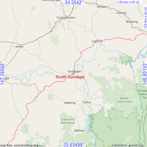
South Gundagai GPS coordinates[2]
35° 4' 53.832" South, 148° 5' 55.68" East
| Map corner | latitude | longitude |
|---|---|---|
| Upper-left | -34.5042°, | 147.39568° |
| Center: | -35.08162°, | 148.0988° |
| Lower-right: | -35.65498°, | 148.80193° |
| Map W x H: | 128×128 km | = 79.5×79.5mi |
| max Lat: | -10.58257° ⇑72.9% North |
| South Gundagai: | -35.08162° |
| min Lat: | ⇓27.1% South -43.31423° |
| min Long | South Gundagai | max Long |
| 113.53327° | 148.0988° | 153.61246° |
| W 51.1%⇐ | ⇒48.9% E |
Elevation
Elevation of South Gundagai is 265 m = 869 ft, and this is 143 m = 469 ft above average elevation for this country.
| Max E: |
1715 m = 5627 ft | 14% |
| South Gundagai | 265 m 869 ft | |
| Avg. | 122 m = 400 ft | |
Min E: |
-2 m = -7 ft | 86% |
See also: Australia elevation on elevation.city.
Geographical zone
South Gundagai is located in South temperate zone (between Tropic of Capricorn and the Antarctic Circle). Distance of this Southern Tropic circle is 1294.8 km =804.6 mi to North.| Distance of | km | miles | from South Gundagai |
|---|---|---|---|
| Equator | 3900.7 | 2423.8 | to North |
| Tropic Capricorn | 1294.8 | 804.6 | to North |
| Antarctic Circle | 3500.5 | 2175.1 | to South |
| South Pole | 6106.4 | 3794.3 | to South |


Nearby cities:
15 places around South Gundagai: (largest is in red/bold)
• Adelong
25 km =15.5 mi,  186°
186°
• Batlow
48.9 km =30.4 mi,  174°
174°
• Binalong
66.8 km =41.5 mi,  47°
47°
• Boorooma
66.8 km =41.5 mi,  270°
270°
• Charles Sturt University
67.8 km =42.1 mi, 271°
• Cootamundra
49.4 km =30.7 mi,  352°
352°
• Estella
67.5 km =41.9 mi, 270°
• Forest Hill
57.9 km =36 mi,  262°
262°
• Gundagai
2.1 km =1.3 mi,  12°
12°
• Junee
52.7 km =32.7 mi,  296°
296°
• Kooringal
66 km =41 mi, 264°
• Lake Albert
65.8 km =40.9 mi, 261°
• Tatton
67.9 km =42.2 mi, 262°
• Tumut
27.2 km =16.9 mi,  156°
156°
• Turvey Park
67.2 km =41.8 mi, 265°
Sources, notices
• [Note1] Compared only with cities in Australia existing in our database
• [Src1] Map data: © OpenStreetMap contributors (CC-BY-SA)
• [Src2] Other city data from geonames.org with taken over terms of usage.
• [Src3] Geographical zone / Annual Mean Temperature by Robert A. Rohde @ Wikipedia
