Tumbarumba geodata
Tumbarumba (New South Wales) is a populated place; located in Australia in Australia/Sydney (GMT+11) time zone. With population of 1,798 people, there are 3050 cities with bigger population in this country. Compared to other cities in Australia, 77.9% of cities are located further ↑North; 50.9% of cities are located further ←West and 97.5% of cities have lower elevation than Tumbarumba. Note1


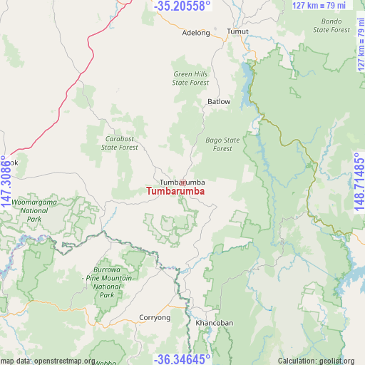
Tumbarumba GPS coordinates[2]
35° 46' 41.016" South, 148° 0' 42.192" East
| Map corner | latitude | longitude |
|---|---|---|
| Upper-left | -35.20558°, | 147.3086° |
| Center: | -35.77806°, | 148.01172° |
| Lower-right: | -36.34645°, | 148.71485° |
| Map W x H: | 126.9×126.9 km | = 78.9×78.9mi |
| max Lat: | -10.58257° ⇑77.9% North |
| Tumbarumba: | -35.77806° |
| min Lat: | ⇓22.1% South -43.31423° |
| min Long | Tumbarumba | max Long |
| 113.53327° | 148.01172° | 153.61246° |
| W 50.9%⇐ | ⇒49.1% E |
Elevation
Elevation of Tumbarumba is 646 m = 2119 ft, and this is 524 m = 1719 ft above average elevation for this country.
| Max E: |
1715 m = 5627 ft | 2.5% |
| Tumbarumba | 646 m 2119 ft | |
| Avg. | 122 m = 400 ft | |
Min E: |
-2 m = -7 ft | 97.5% |
See also: Australia elevation on elevation.city.
Geographical zone
Tumbarumba is located in South temperate zone (between Tropic of Capricorn and the Antarctic Circle). Distance of this Southern Tropic circle is 1372.2 km =852.6 mi to North.| Distance of | km | miles | from Tumbarumba |
|---|---|---|---|
| Equator | 3978.1 | 2471.9 | to North |
| Tropic Capricorn | 1372.2 | 852.6 | to North |
| Antarctic Circle | 3423 | 2127 | to South |
| South Pole | 6028.9 | 3746.2 | to South |


Nearby cities:
15 places around Tumbarumba: (largest is in red/bold)
• Adelong
52.9 km =32.9 mi,  5°
5°
• Batlow
31.2 km =19.4 mi,  23°
23°
• Corryong
47.6 km =29.6 mi,  191°
191°
• Crackenback
86 km =53.4 mi,  149°
149°
• Culcairn
88.7 km =55.1 mi,  278°
278°
• East Jindabyne
89.6 km =55.7 mi,  140°
140°
• Forest Hill
85.7 km =53.3 mi,  324°
324°
• Gundagai
79.9 km =49.6 mi, 5°
• Holbrook
63.1 km =39.2 mi, 275°
• Jindabyne
89.8 km =55.8 mi, 142°
• Kosciuszko National Park
68.6 km =42.6 mi, 141°
• Lake Albert
88.7 km =55.1 mi, 320°
• South Gundagai
77.8 km =48.3 mi, 5°
• Tallangatta
89.6 km =55.7 mi,  236°
236°
• Tumut
55.7 km =34.6 mi, 19°
Sources, notices
• [Note1] Compared only with cities in Australia existing in our database
• [Src1] Map data: © OpenStreetMap contributors (CC-BY-SA)
• [Src2] Other city data from geonames.org with taken over terms of usage.
• [Src3] Geographical zone / Annual Mean Temperature by Robert A. Rohde @ Wikipedia
