Tawonga geodata
Tawonga (Victoria) is a populated place; located in Australia in Australia/Melbourne (GMT+11) time zone. With population of 541 people, there are 4743 cities with bigger population in this country. Compared to other cities in Australia, 80.3% of cities are located further ↑North; 52.3% of cities are located further →East and 88.5% of cities have lower elevation than Tawonga. Note1


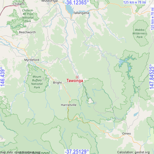
Tawonga GPS coordinates[2]
36° 41' 22.344" South, 147° 8' 31.632" East
| Map corner | latitude | longitude |
|---|---|---|
| Upper-left | -36.12365°, | 146.439° |
| Center: | -36.68954°, | 147.14212° |
| Lower-right: | -37.25129°, | 147.84525° |
| Map W x H: | 125.4×125.4 km | = 77.9×77.9mi |
| max Lat: | -10.58257° ⇑80.3% North |
| Tawonga: | -36.68954° |
| min Lat: | ⇓19.7% South -43.31423° |
| min Long | Tawonga | max Long |
| 113.53327° | 147.14212° | 153.61246° |
| W 47.7%⇐ | ⇒52.3% E |
Elevation
Elevation of Tawonga is 326 m = 1070 ft, and this is 204 m = 669 ft above average elevation for this country.
| Max E: |
1715 m = 5627 ft | 11.5% |
| Tawonga | 326 m 1070 ft | |
| Avg. | 122 m = 400 ft | |
Min E: |
-2 m = -7 ft | 88.5% |
See also: Australia elevation on elevation.city.
Geographical zone
Tawonga is located in South temperate zone (between Tropic of Capricorn and the Antarctic Circle). Distance of this Southern Tropic circle is 1473.6 km =915.7 mi to North.| Distance of | km | miles | from Tawonga |
|---|---|---|---|
| Equator | 4079.5 | 2534.9 | to North |
| Tropic Capricorn | 1473.6 | 915.7 | to North |
| Antarctic Circle | 3321.7 | 2064 | to South |
| South Pole | 5927.6 | 3683.2 | to South |


Nearby cities:
15 places around Tawonga: (largest is in red/bold)
• Bandiana
63.3 km =39.3 mi,  342°
342°
• Baranduda
57.9 km =36 mi, 343°
• Beechworth
54.9 km =34.1 mi,  312°
312°
• Bonegilla
62.3 km =38.7 mi,  348°
348°
• Bright
16.9 km =10.5 mi,  254°
254°
• Dinner Plain
38.2 km =23.7 mi,  166°
166°
• Falls Creek
23 km =14.3 mi,  148°
148°
• Hotham Heights
33.8 km =21 mi,  178°
178°
• Leneva
56.9 km =35.4 mi, 337°
• Mount Beauty
6 km =3.7 mi, 150°
• Myrtleford
40 km =24.9 mi,  290°
290°
• Porepunkah
20.7 km =12.9 mi,  267°
267°
• Tallangatta
52.5 km =32.6 mi,  3°
3°
• Tangambalanga
49.7 km =30.9 mi, 348°
• Yackandandah
49.8 km =30.9 mi,  327°
327°
Sources, notices
• [Note1] Compared only with cities in Australia existing in our database
• [Src1] Map data: © OpenStreetMap contributors (CC-BY-SA)
• [Src2] Other city data from geonames.org with taken over terms of usage.
• [Src3] Geographical zone / Annual Mean Temperature by Robert A. Rohde @ Wikipedia
