Bright geodata
Bright (Victoria) is a populated place; located in Australia in Australia/Melbourne (GMT+11) time zone. With population of 2,546 people, there are 2535 cities with bigger population in this country. Compared to other cities in Australia, 80.5% of cities are located further ↑North; 53.3% of cities are located further →East and 88% of cities have lower elevation than Bright. Note1


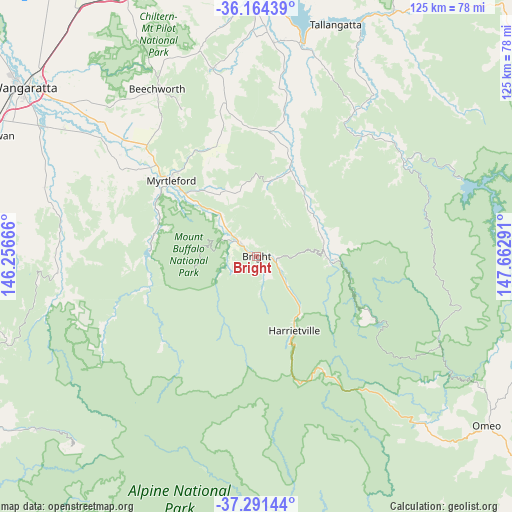
Bright GPS coordinates[2]
36° 43' 47.928" South, 146° 57' 35.208" East
| Map corner | latitude | longitude |
|---|---|---|
| Upper-left | -36.16439°, | 146.25666° |
| Center: | -36.72998°, | 146.95978° |
| Lower-right: | -37.29144°, | 147.66291° |
| Map W x H: | 125.3×125.3 km | = 77.9×77.9mi |
| max Lat: | -10.58257° ⇑80.5% North |
| Bright: | -36.72998° |
| min Lat: | ⇓19.5% South -43.31423° |
| min Long | Bright | max Long |
| 113.53327° | 146.95978° | 153.61246° |
| W 46.7%⇐ | ⇒53.3% E |
Elevation
Elevation of Bright is 315 m = 1033 ft, and this is 193 m = 633 ft above average elevation for this country.
| Max E: |
1715 m = 5627 ft | 12% |
| Bright | 315 m 1033 ft | |
| Avg. | 122 m = 400 ft | |
Min E: |
-2 m = -7 ft | 88% |
See also: Australia elevation on elevation.city.
Geographical zone
Bright is located in South temperate zone (between Tropic of Capricorn and the Antarctic Circle). Distance of this Southern Tropic circle is 1478.1 km =918.4 mi to North.| Distance of | km | miles | from Bright |
|---|---|---|---|
| Equator | 4084 | 2537.7 | to North |
| Tropic Capricorn | 1478.1 | 918.4 | to North |
| Antarctic Circle | 3317.2 | 2061.2 | to South |
| South Pole | 5923.1 | 3680.4 | to South |


Nearby cities:
15 places around Bright: (largest is in red/bold)
• Baranduda
59.9 km =37.2 mi,  359°
359°
• Beechworth
48 km =29.8 mi,  329°
329°
• Dinner Plain
41.1 km =25.5 mi,  142°
142°
• Falls Creek
32.1 km =19.9 mi,  117°
117°
• Hotham Heights
33.9 km =21.1 mi,  149°
149°
• Leneva
57.3 km =35.6 mi,  354°
354°
• Milawa
57.4 km =35.7 mi,  305°
305°
• Mount Beauty
19.2 km =11.9 mi,  92°
92°
• Myrtleford
28.2 km =17.5 mi, 311°
• Oxley
61.4 km =38.2 mi,  300°
300°
• Porepunkah
5.8 km =3.6 mi, 310°
• Tallangatta
60.2 km =37.4 mi,  18°
18°
• Tangambalanga
53.5 km =33.2 mi,  6°
6°
• Tawonga
16.9 km =10.5 mi,  74°
74°
• Yackandandah
47.5 km =29.5 mi, 346°
Sources, notices
• [Note1] Compared only with cities in Australia existing in our database
• [Src1] Map data: © OpenStreetMap contributors (CC-BY-SA)
• [Src2] Other city data from geonames.org with taken over terms of usage.
• [Src3] Geographical zone / Annual Mean Temperature by Robert A. Rohde @ Wikipedia
