Falls Creek geodata
Falls Creek (Victoria) is a populated place; located in Australia in Australia/Melbourne (GMT+11) time zone. With population of 3,288 people, there are 2071 cities with bigger population in this country. Compared to other cities in Australia, 81.2% of cities are located further ↑North; 51.4% of cities are located further →East and 99.9% of cities have lower elevation than Falls Creek. Note1


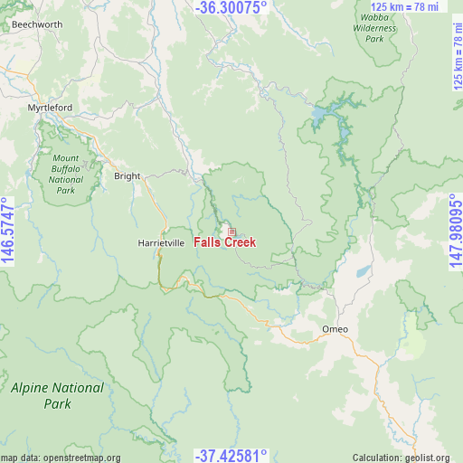
Falls Creek GPS coordinates[2]
36° 51' 55.26" South, 147° 16' 40.152" East
| Map corner | latitude | longitude |
|---|---|---|
| Upper-left | -36.30075°, | 146.5747° |
| Center: | -36.86535°, | 147.27782° |
| Lower-right: | -37.42581°, | 147.98095° |
| Map W x H: | 125.1×125.1 km | = 77.7×77.7mi |
| max Lat: | -10.58257° ⇑81.2% North |
| Falls Creek: | -36.86535° |
| min Lat: | ⇓18.8% South -43.31423° |
| min Long | Falls Creek | max Long |
| 113.53327° | 147.27782° | 153.61246° |
| W 48.6%⇐ | ⇒51.4% E |
Elevation
Elevation of Falls Creek is 1592 m = 5223 ft, and this is 1470 m = 4823 ft above average elevation for this country.
| Max E: |
1715 m = 5627 ft | 0.099999999999994% |
| Falls Creek | 1592 m 5223 ft | |
| Avg. | 122 m = 400 ft | |
Min E: |
-2 m = -7 ft | 99.9% |
See also: Australia elevation on elevation.city.
Geographical zone
Falls Creek is located in South temperate zone (between Tropic of Capricorn and the Antarctic Circle). Distance of this Southern Tropic circle is 1493.1 km =927.8 mi to North.| Distance of | km | miles | from Falls Creek |
|---|---|---|---|
| Equator | 4099 | 2547 | to North |
| Tropic Capricorn | 1493.1 | 927.8 | to North |
| Antarctic Circle | 3302.1 | 2051.8 | to South |
| South Pole | 5908 | 3671.1 | to South |


Nearby cities:
15 places around Falls Creek: (largest is in red/bold)
• Baranduda
80.4 km =50 mi,  338°
338°
• Beechworth
77.3 km =48 mi,  316°
316°
• Bonegilla
84.2 km =52.3 mi, 343°
• Bright
32.1 km =19.9 mi,  297°
297°
• Dinner Plain
17.9 km =11.1 mi,  190°
190°
• Hotham Heights
18.1 km =11.2 mi,  218°
218°
• Leneva
79.6 km =49.5 mi,  334°
334°
• Mount Beauty
17 km =10.6 mi, 327°
• Mount Buller
80.9 km =50.3 mi,  247°
247°
• Myrtleford
59.9 km =37.2 mi, 304°
• Porepunkah
37.8 km =23.5 mi, 299°
• Tallangatta
72.5 km =45 mi,  352°
352°
• Tangambalanga
71.7 km =44.6 mi, 341°
• Tawonga
23 km =14.3 mi, 328°
• Yackandandah
72.8 km =45.2 mi, 327°
Sources, notices
• [Note1] Compared only with cities in Australia existing in our database
• [Src1] Map data: © OpenStreetMap contributors (CC-BY-SA)
• [Src2] Other city data from geonames.org with taken over terms of usage.
• [Src3] Geographical zone / Annual Mean Temperature by Robert A. Rohde @ Wikipedia
