Myrtleford geodata
Myrtleford (Victoria) is a populated place; located in Australia in Australia/Melbourne (GMT+11) time zone. With population of 3,081 people, there are 2201 cities with bigger population in this country. Compared to other cities in Australia, 80.1% of cities are located further ↑North; 54.7% of cities are located further →East and 82.4% of cities have lower elevation than Myrtleford. Note1


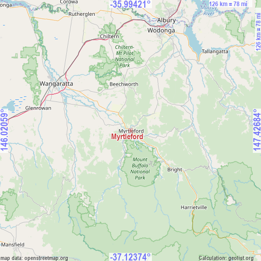
Myrtleford GPS coordinates[2]
36° 33' 39.744" South, 146° 43' 25.356" East
| Map corner | latitude | longitude |
|---|---|---|
| Upper-left | -35.99421°, | 146.02059° |
| Center: | -36.56104°, | 146.72371° |
| Lower-right: | -37.12374°, | 147.42684° |
| Map W x H: | 125.6×125.6 km | = 78×78mi |
| max Lat: | -10.58257° ⇑80.1% North |
| Myrtleford: | -36.56104° |
| min Lat: | ⇓19.9% South -43.31423° |
| min Long | Myrtleford | max Long |
| 113.53327° | 146.72371° | 153.61246° |
| W 45.3%⇐ | ⇒54.7% E |
Elevation
Elevation of Myrtleford is 210 m = 689 ft, and this is 88 m = 289 ft above average elevation for this country.
| Max E: |
1715 m = 5627 ft | 17.6% |
| Myrtleford | 210 m 689 ft | |
| Avg. | 122 m = 400 ft | |
Min E: |
-2 m = -7 ft | 82.4% |
See also: Australia elevation on elevation.city.
Geographical zone
Myrtleford is located in South temperate zone (between Tropic of Capricorn and the Antarctic Circle). Distance of this Southern Tropic circle is 1459.3 km =906.8 mi to North.| Distance of | km | miles | from Myrtleford |
|---|---|---|---|
| Equator | 4065.2 | 2526 | to North |
| Tropic Capricorn | 1459.3 | 906.8 | to North |
| Antarctic Circle | 3336 | 2072.9 | to South |
| South Pole | 5941.9 | 3692.1 | to South |


Nearby cities:
15 places around Myrtleford: (largest is in red/bold)
• Baranduda
46 km =28.6 mi,  26°
26°
• Beechworth
22.8 km =14.2 mi,  351°
351°
• Bright
28.2 km =17.5 mi,  131°
131°
• Chiltern
46.8 km =29.1 mi, 347°
• Glenrowan
45.9 km =28.5 mi,  283°
283°
• Leneva
41.4 km =25.7 mi,  22°
22°
• Milawa
29.6 km =18.4 mi,  298°
298°
• Mount Beauty
44.8 km =27.8 mi,  115°
115°
• Oxley
34.2 km =21.3 mi,  291°
291°
• Porepunkah
22.4 km =13.9 mi, 132°
• Tangambalanga
43.9 km =27.3 mi,  38°
38°
• Tawonga
40 km =24.9 mi,  110°
110°
• Waldara
47.6 km =29.6 mi, 304°
• Wangaratta
42.5 km =26.4 mi, 301°
• Yackandandah
29.4 km =18.3 mi, 20°
Sources, notices
• [Note1] Compared only with cities in Australia existing in our database
• [Src1] Map data: © OpenStreetMap contributors (CC-BY-SA)
• [Src2] Other city data from geonames.org with taken over terms of usage.
• [Src3] Geographical zone / Annual Mean Temperature by Robert A. Rohde @ Wikipedia
