Beechworth geodata
Beechworth (Victoria) is a populated place; located in Australia in Australia/Melbourne (GMT+11) time zone. With population of 3,761 people, there are 1894 cities with bigger population in this country. Compared to other cities in Australia, 79.5% of cities are located further ↑North; 54.9% of cities are located further →East and 94.1% of cities have lower elevation than Beechworth. Note1


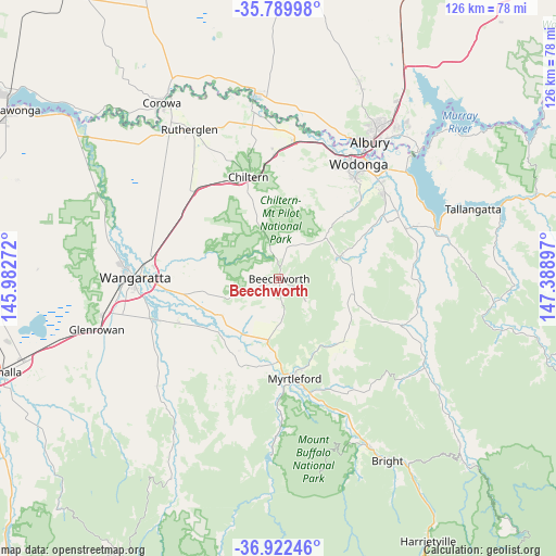
Beechworth GPS coordinates[2]
36° 21' 29.808" South, 146° 41' 9.024" East
| Map corner | latitude | longitude |
|---|---|---|
| Upper-left | -35.78998°, | 145.98272° |
| Center: | -36.35828°, | 146.68584° |
| Lower-right: | -36.92246°, | 147.38897° |
| Map W x H: | 125.9×125.9 km | = 78.2×78.2mi |
| max Lat: | -10.58257° ⇑79.5% North |
| Beechworth: | -36.35828° |
| min Lat: | ⇓20.5% South -43.31423° |
| min Long | Beechworth | max Long |
| 113.53327° | 146.68584° | 153.61246° |
| W 45.1%⇐ | ⇒54.9% E |
Elevation
Elevation of Beechworth is 548 m = 1798 ft, and this is 426 m = 1398 ft above average elevation for this country.
| Max E: |
1715 m = 5627 ft | 5.9% |
| Beechworth | 548 m 1798 ft | |
| Avg. | 122 m = 400 ft | |
Min E: |
-2 m = -7 ft | 94.1% |
See also: Australia elevation on elevation.city.
Geographical zone
Beechworth is located in South temperate zone (between Tropic of Capricorn and the Antarctic Circle). Distance of this Southern Tropic circle is 1436.7 km =892.7 mi to North.| Distance of | km | miles | from Beechworth |
|---|---|---|---|
| Equator | 4042.7 | 2512 | to North |
| Tropic Capricorn | 1436.7 | 892.7 | to North |
| Antarctic Circle | 3358.5 | 2086.9 | to South |
| South Pole | 5964.4 | 3706.1 | to South |


Nearby cities:
15 places around Beechworth: (largest is in red/bold)
• Bandiana
31.8 km =19.8 mi,  42°
42°
• Baranduda
30.4 km =18.9 mi,  52°
52°
• Barnawartha
28.3 km =17.6 mi,  358°
358°
• Chiltern
24.1 km =15 mi,  343°
343°
• Killara
34 km =21.1 mi, 44°
• Leneva
24.8 km =15.4 mi, 50°
• Milawa
24.1 km =15 mi,  249°
249°
• Myrtleford
22.8 km =14.2 mi,  171°
171°
• Oxley
30.3 km =18.8 mi, 250°
• Tangambalanga
32.9 km =20.4 mi,  68°
68°
• Wangaratta
32.7 km =20.3 mi,  269°
269°
• West Albury
36.1 km =22.4 mi,  30°
30°
• West Wodonga
30.1 km =18.7 mi, 29°
• Wodonga
31.9 km =19.8 mi, 34°
• Yackandandah
14.6 km =9.1 mi, 70°
Sources, notices
• [Note1] Compared only with cities in Australia existing in our database
• [Src1] Map data: © OpenStreetMap contributors (CC-BY-SA)
• [Src2] Other city data from geonames.org with taken over terms of usage.
• [Src3] Geographical zone / Annual Mean Temperature by Robert A. Rohde @ Wikipedia
